Timiskamingsee
| Lac Témiscamingue Lake Timiskaming |
|||||||||
|---|---|---|---|---|---|---|---|---|---|
|
|||||||||
|
|
|||||||||
| Coordinates | 47 ° 10 '2 " N , 79 ° 26' 12" W | ||||||||
| Data on the structure | |||||||||
| Construction time: | 1911-1914 | ||||||||
| Operator: | Public Works and Government Services Canada (PWGSC) | ||||||||
| Data on the reservoir | |||||||||
| Altitude (at congestion destination ) | 178 m | ||||||||
| Water surface | 306 km² | ||||||||
| Reservoir length | 108 km | ||||||||
| Reservoir width | 9 km | ||||||||
| Storage space | 1217 million m³ | ||||||||
| View from Fort Témiscamingue to the south over the lake, near Ville-Marie (Québec) | |||||||||
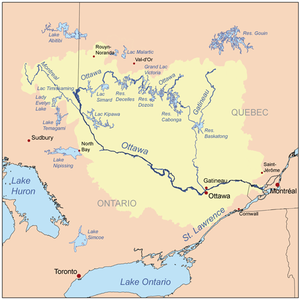
| Location of the reservoir in the catchment area of the Ottawa River | |||||||||
The Timiskamingsee ( English Lake Timiskaming ; French Lac Témiscamingue ) is a reservoir on the border between the Canadian provinces of Ontario (on the west bank) and Québec (on the east bank).
It covers an area of 306 km² and stretches 108 km from north to south. At its widest point it is about 9 km wide. In the lake are the two populated islands Île Mann and Île du Collège . In addition to the upper reaches of the Ottawa River ( Rivière des Outaouais ), important tributaries of the reservoir are the Montreal River , the Rivière Kipawa and the Blanche River . The only outflow is the Ottawa River, from which it flows along its entire length. Waterfront locations are Ville-Marie , New Liskeard and Témiscaming .
The Ottawa River is dammed at Témiscaming by two dams - one in Québec and one in Ontario. These were built in the years 1911–1914. In between lies the river island Long Sault Island . The purpose of the facility operated by Public Works and Government Services Canada (PWGSC) is flow control and flood protection. The storage capacity of the reservoir is 1217 million m³.
A road runs over the crest of the two dams and connects Ontario Highway 63 with Route 101 in Québec.
Web links
Individual evidence
- ↑ the spelling of all geographical, historical or political units in this border area between Ontario and Quebec varies both at the beginning and at the end of the word, partly because of the two Canadian national languages.
- ^ Commission de toponymie du Québec - Lac Témiscamingue
- ↑ a b ( page no longer available , search in web archives: ottawariverkeeper.ca ) (PDF).


