Tinkisso
| Tinkisso | ||
|
The Tinkisso (top center) |
||
| Data | ||
| location |
|
|
| River system | Niger | |
| Drain over | Niger → Atlantic | |
| source | In the mountains of Fouta Djallon | |
| muzzle | at Siguiri in Niger Coordinates: 11 ° 21 ′ 16 " N , 9 ° 9 ′ 49" W 11 ° 21 ′ 16 " N , 9 ° 9 ′ 49" W |
|
| Mouth height |
341 m
|
|
| length | 570 km | |
| Catchment area | 19,430 km² | |
| Discharge at the Ouaran gauge (1634600) A Eo : 18,700 km² Location: 30 km above the mouth |
NNQ (min. Month Ø) MNQ 1954–1978 MQ 1954–1978 Mq 1954–1978 MHQ 1954–1978 HHQ (max. Month Ø) |
1 m³ / s 11 m³ / s 181 m³ / s 9.7 l / (s km²) 623 m³ / s 1150 m³ / s |
| Left tributaries | Bouka | |
|
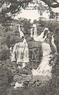
The Tinkisso Falls (around 1905) |
||
The Tinkisso is a 570 km long river in Guinea ( West Africa ).
course
The river has its source in Fouta Djallon . It flows first to the northeast. After a good 200 km it swings to the east, where it picks up the bouka. The Tinkisso flows into the Niger at the heights of Siguiri .
The strongly meandering Tinkisso has an annual discharge of 181 m³ / s and drains a basin of 19,430 km².
Hydrometry
Average monthly flow of the Tinkisso measured at the hydrological station near Ouaran in m³ / s.

literature
Alpha Mamadou Bah: Geography, la République de Guinée . Domaine de l'éducation et de la culture, Ministère de l'enseignement supérieur et de tele-enseignement, Conakry 1974.

