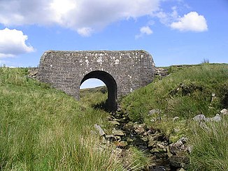
Tinnis Burn
| Tinnis Burn | ||
|
The Tinnis Burn and the Tinnis Bridge |
||
| Data | ||
| location | Scottish Borders , Scotland | |
| River system | River Esk (Solway Firth) | |
| Drain over | Liddel Water → River Esk (Solway Firth) → Solway Firth → Irish Sea | |
| River basin district | Solway Tweed XRBD | |
| source | south of Cooms Fell 55 ° 10 ′ 53 ″ N , 2 ° 53 ′ 37 ″ W |
|
| muzzle | in the Liddel Water Coordinates: 55 ° 8 ′ 22 " N , 2 ° 49 ′ 31" W 55 ° 8 ′ 22 " N , 2 ° 49 ′ 31" W
|
|
| Left tributaries | Stanygill Burn | |
| Right tributaries | Todhunter Grain | |
The Tinnis Burn is a watercourse in the Scottish Borders , Scotland . It arises south of the Cooms Fell and flows in a south-easterly direction to its confluence with the Liddel Water on its western side of the river, west of the hamlet of Kershopefoot on the eastern side .
