
Tokara Islands
| Tokara Islands | ||
|---|---|---|
 |
||
| Waters | East China Sea | |
| archipelago | Satsunan Islands | |
| Geographical location | 29 ° 23 ' N , 129 ° 27' E | |
|
||
| Number of islands | 12 | |
| Total land area | 101.35 km² | |
| Residents | 761 (October 1, 2019) | |

The Tokara Islands ( Japanese 吐 噶 喇 列島 or simplified ト カ ラ 列島 , Tokara-rettō ) are a chain of islands in southwest Japan , which belongs to the Ryūkyū Islands or Nansei Islands , which have existed as a political region since 1970.
The island chain consists of 12 small islands between Yakushima and Amami-Ōshima . The islands have a total area of 101.35 km² and the island chain is almost 150 km long. Administratively it belongs to the village of Toshima and seven islands are inhabited by 761 people.
The Tokara Islands, especially Takara-jima Island, are home to the Tokara pony and Kuchinoshima is the only habitat of the Lilium nobilissimum lily species .
etymology
The community of Toshima gives two theories as meaning for Tokara: On the one hand, it is said to come from the word tohara , which roughly means distant sea area ( 沖 の 海原 ) and refers to the view of the Amami and Okinawa Islands . On the other hand, however, it could also come from the Ainu word tokap , which means breast. This is said to refer to the mountain Megami-yama ( 女神 山 , "goddess mountain") on the island of Takara-jima, which first gave this island its name and then the entire chain of islands. However, the Ainu live in northern Japan .
history
The Shoku Nihongi mentions, together with Tane , Yaku and Amami, an island called Tokan ( 度 感 ) for the year 699 , which is usually identified with Tokara and is then the first mention of it, but could also refer to Tokunoshima 150 km away . Occasionally, an earlier mention in the Nihon Shoki for the year 654 is used. However, the "Land Tokara" ( 吐火羅 国 , Tokara no kuni ) mentioned there probably denotes Tukhāra , the land of the Tochars .
In 1908, the islands were under the administration of the village of Jittō ( 十 島村 , - son , literally: "ten islands"), in addition to the seven inhabited Tokara Islands, the inhabited islands of Iōjima , Kuroshima and Takeshima to the north also belonged. After the Second World War , the islands south of the 30th parallel, and thus also the Tokara Islands, were placed under US administration on February 2, 1946. On February 10, 1952, the islands were returned to Japan and the municipality of Toshima was founded, which spells the same as Jittō, but no longer administers the northern three islands - these form a separate municipality called Mishima .
Islands
The island chain is made up of the following islands:
| image | Surname | Kanji | Area [km²] |
2004 residents |
highest point [m] |
summit | Coordinates |
|---|---|---|---|---|---|---|---|
| Kuchinoshima | 口 之 島 | 13.33 | 140 | 628.5 | Maedake | 29 ° 58 ' N , 129 ° 55' E | |
|
|
Nakanoshima | 中 之 島 | 34.47 | 167 | 979.0 | Otake | 29 ° 51 ' N , 129 ° 53' E |
|
|
Gaja-jima | 臥 蛇島 | 4.07 | - | 497.2 | 29 ° 54 ' N , 129 ° 33' E | |
|
|
Kogaja-jima | 小 臥 蛇島 | 0.5 | - | 301 | 29 ° 53 ' N , 129 ° 37' E | |

|
Taira-jima | 平 島 | 2.08 | 79 | 242.9 | Otake | 29 ° 41 ' N , 129 ° 32' E |
|
|
Suwanose-jima | 諏 訪 之 瀬 島 | 27.66 | 48 | 796 | Otake | 29 ° 38 ' N , 129 ° 43' E |
|
|
Akuseki-jima | 悪 石島 | 7.49 | 72 | 584.0 | Mitake | 29 ° 28 ' N , 129 ° 36' E |
| Kojima | 小島 | 0.36 | - | 56 | 29 ° 14 ' N , 129 ° 21' E | ||
| Kodakara-jima | 小 宝島 | 1.00 | 43 | 102.7 | 29 ° 13 ' N , 129 ° 20' E | ||
|
|
Takara-jima | 宝島 | 7.14 | 114 | 291.9 | Imakira-dake | 29 ° 9 ' N , 129 ° 12' E |
|
|
Kaminone-jima | 上 ノ 根 島 | 0.54 | - | 280 | 28 ° 50 ' N , 129 ° 0' E | |
|
|
Yokoate-jima | 横 当 島 | 2.76 | - | 494.8 | 28 ° 48 ' N , 128 ° 59' E | |
|
|
|||||||
Web links
- Tokara Islands Website (Japanese)
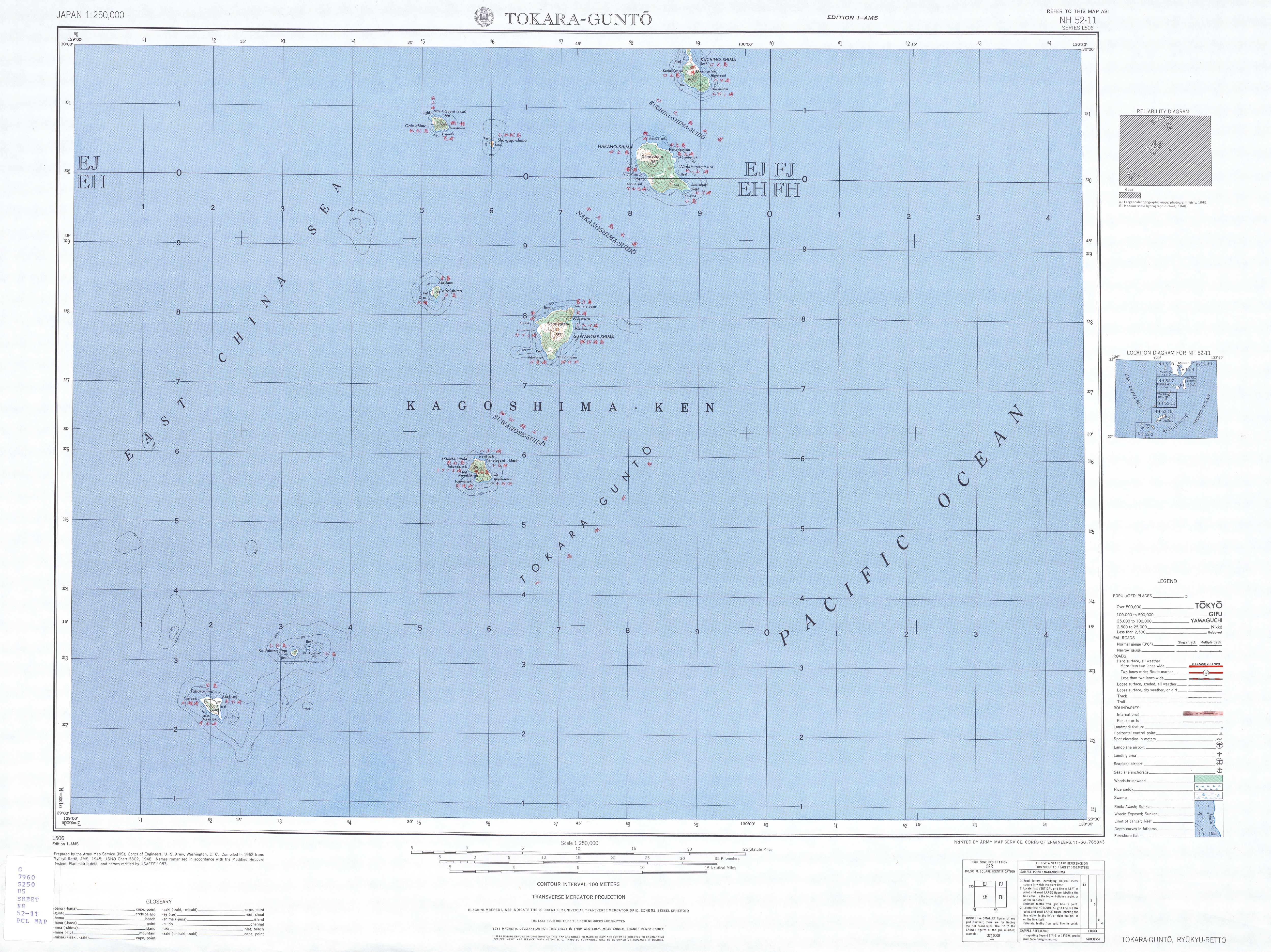
- Topographic map 1: 250,000
Individual evidence
- ↑ Ajiro Tatsuhiko and Warita Ikuo, Waga kuni no kōiki na chimei oyobi sono han'i ni tsuite no chōsa kenkyū (The geographical names and those extents of the wide areas in Japan), Kaiyō Jōhōbu Gihō, Vol. 27, 2009.
- ↑ a b c 十 島村 の 概要 . Toshima, accessed January 14, 2011 (Japanese).
- ^ Ethnic Studies Oral History Project, University of Hawaii at Manoa: Uchinanchu: A History of Okinawans in Hawaii . University of Hawaii Press, 1981, ISBN 978-0-8248-0749-8 , pp. 6 ( limited preview in Google Book search).
- ↑ Digitized version of Shoku Nihongi , fascicle 1 : ○ 秋 七月 辛未。 多 〓。 夜 久。 菴 美。 度 感 等 人。 従 朝 宰 宰 而来 貢 方 物。 授 位 賜 物 各有 差。 其 度 感 嶋通 中国 、 於是 始 矣。
- ↑ David Waterhouse: Where did Toragaku come from? In: Musica Asiatica . tape 6 . Cambridge University Press, 1991, ISBN 0-521-39050-8 , pp. 75 ( limited preview in Google Book search).
- ↑ 人口 . (PDF; 19 kB) (No longer available online.) Toshima, archived from the original on July 4, 2011 ; Retrieved January 13, 2011 (Japanese). Info: The archive link was inserted automatically and has not yet been checked. Please check the original and archive link according to the instructions and then remove this notice.