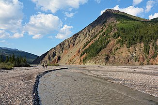
Toklat River
| Toklat River | ||
| Data | ||
| Water code | US : 1411054 | |
| location | Alaska (USA) | |
| River system | Yukon River | |
| Drain over | Kantishna River → Tanana River → Yukon River → Bering Sea | |
| origin | nameless glacier on the northern flank of the Alaska range 63 ° 23 ′ 25 ″ N , 149 ° 54 ′ 51 ″ W |
|
| Source height | approx. 1400 m | |
| muzzle |
Kantishna River Coordinates: 64 ° 27 ′ 15 " N , 150 ° 18 ′ 43" W 64 ° 27 ′ 15 " N , 150 ° 18 ′ 43" W. |
|
| Mouth height | 115 m | |
| Height difference | approx. 1285 m | |
| Bottom slope | approx. 9.2 ‰ | |
| length | approx. 140 km | |
| Right tributaries | East Fork Toklat River, Sushana River | |
| East Fork Toklat River | ||
| Data | ||
| Water code | US : 1401613 | |
| location | Alaska (USA) | |
| River system | Yukon River | |
| Drain over | Kantishna River → Tanana River → Yukon River → Bering Sea | |
| origin | nameless glacier on the northern flank of the Alaska range 63 ° 27 ′ 24 ″ N , 149 ° 40 ′ 50 ″ W |
|
| Source height | approx. 1350 m | |
| muzzle | Toklat River 63 ° 54 ′ 13 ″ N , 150 ° 9 ′ 0 ″ W. |
|
| Mouth height | 396 m | |
| Height difference | approx. 954 m | |
| Bottom slope | approx. 16 ‰ | |
| length | approx. 60 km | |
The Toklat River is a right tributary of the Kantishna River in central Alaska .
The Toklat River rises on the northern flank of the Alaska range . The road through Denali National Park crosses the river not far from its formation. The Toklat River flows in a predominantly northerly direction and takes on the East Fork Toklat River from the right. After about 140 km it reaches the Kantishna River . The Toklat River has many parallel river arms in the upper and middle reaches. This section of the river lies within Denali National Park. In the lower 40 km to its mouth, the river changes its character and forms countless narrow meanders .
East Fork Toklat River
The East Fork Toklat River is a 60 km long right tributary of the Toklat River. It is fed by a nameless glacier on the northern flank of the Alaska range. The river flows in a predominantly north-northwest direction. It is fed by several glacial rivers. The Polychrome Glacier is located in the catchment area of the East Fork Toklat River.


