Tonaki-jima
| Tonaki-jima | ||
|---|---|---|
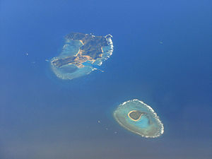
| Tonaki-jima (above) and Irisuna-jima (below) | ||
| Waters | East China Sea | |
| Archipelago | Okinawa Islands | |
| Geographical location | 26 ° 22 '0 " N , 127 ° 8' 50" E | |
|
|
||
| length | 3 km | |
| surface | 3.58 km² | |
| Highest elevation | Ūtaki 179 m |
|
| Residents | 401 (October 1, 2019) 112 inhabitants / km² |
|
Tonaki-jima ( Japanese 渡 名 喜 島 , Okinawa : Tunachi ) is an island of the Japanese Ryūkyū island chain .
geography
Tonaki-jima is located about 20 km northwest of Zamami-jima of the Kerama Islands , east of the offshore coral reef or its elevation Ugan-saki near Kume-jima and south of Aguni-jima . The neighboring island of Irisuna-jima is about 3.5 km to the northwest . Together with this Tonaki-jima belongs to the municipality of Tonaki , although only Tonaki-jima is inhabited, while Irisuna-jima is a US military area. In addition, about 50 m off the southeast coast of Tonaki-jima is the one-hectare island of Shimajiri-saki ( 島 尻 崎 ).
Only a strip of flat land between the 145.9 m high Nishimui (
Individual evidence
- ↑ 沖 縄 県 推 計 人口 デ ー タ 一 覧 (Excel 形式) . 沖 縄 県 , October 1, 2019, accessed October 31, 2019 (Japanese).
- ↑ ト ゥ ナ チ . In: 語彙 詳細 - 首 里 ・ 那覇 方言 . Retrieved December 2, 2012 (Japanese).
- ↑ 指定 離島 ・ 指定 離島 一 覧 . (PDF) In: 離島 関係 資料 (平 成 28 年 1 月) . 沖 縄 県 企 画 部 地域 ・ 離島 課 ("Land and Islands Unit, Planning Department, Okinawa Prefecture"), January 2016, p. 1 , accessed on 3. August 2016 (Japanese).
- ↑ official topographic map

