
Toroni (municipality)
|
Toroni municipality Δημοτική Ενότητα Τορώνης (Τορώνη) |
|||
|---|---|---|---|
|
|||
| Basic data | |||
| State : |
|
||
| Region : |
Central Macedonia
|
||
| Regional District : | Chalkidiki | ||
| Municipality : | Sithonia | ||
| Geographic coordinates : | 40 ° 2 ′ N , 23 ° 55 ′ E | ||
| Height above d. M .: | 0 to 689 m sea & mountain Dragoudelis |
||
| Area : | 193.973 km² | ||
| Residents : | 3,553 (2011) | ||
| Population density : | 18.3 inhabitants / km² | ||
| Code No .: | 130502 | ||
| Structure: |
1 city district 1 local community |
||
| Website: | www.pallini.gr | ||
| Located in the municipality of Sithonia and in the regional district of Chalkidiki | |||
 |
|||

Toroni ( Greek Τορώνη ( f. Sg. ); Official name Dimotiki Enotita Toronis Δημοτική Ενότητα Τορώνης) is the southern municipality of the municipality of Sithonia on the Chalkidiki peninsula in the Greek region of Central Macedonia . From 1997 to 2010 Toroni was an independent municipality with the administrative center in the village of Sykia. The municipalities of Sarti , which were independent until 1997, with the village of Toroni and Sykia , now form localities. The name Toroni was chosen based on the ancient city of Toroni, whose rulership temporarily corresponded to the current municipal area.
For the administrative structure, see the article on today's municipality .
The small settlement of Tristinika, located north of Toroni, is not included in the official census data.
Picture gallery

View of the Kriaritsi landscape in the Sykia municipality

View of the Lekythos peninsula with the remains of the ancient city of Toroni, Sykia municipality

Entrance to the natural harbor Porto Koufo in the municipality of Sykia
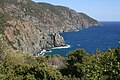
On the cliffs southeast of Porto Koufo

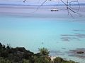
View of the bay from Ambelos Beach
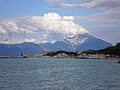
View of Mount Athos from Kavourotrypes Beach, Sykia Municipality

Tourkolimano beach near Sykia
Kavourotrypes Beach, Sykia
_-_004.jpg)


literature
- Halkidiki 1: 150,000. Road Editions, Athens. ISBN 960-8481-90-2 .
Individual evidence
- ↑ Results of the 2011 census, Greek Statistical Office (ΕΛ.ΣΤΑΤ) ( Memento from June 27, 2015 in the Internet Archive ) (Excel document, 2.6 MB)