Cheryocha
|
Cheryokha River Черёха |
||
|
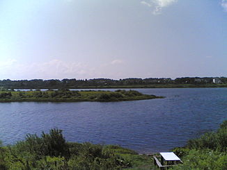
Mouth of the Cherjocha into the Velikaya |
||
| Data | ||
| Water code | RU : 01030000212102000029133 | |
| location | Pskov Oblast ( Russia ) | |
| River system | Narva | |
| Drain over | Velikaya → Narva → Baltic Sea | |
| origin | in the small lake Tschereschno in Ostrov Raion 57 ° 14 ′ 26 ″ N , 28 ° 42 ′ 6 ″ E |
|
| muzzle | in Velikaya coordinates: 57 ° 46 ′ 11 " N , 28 ° 21 ′ 35" E 57 ° 46 ′ 11 " N , 28 ° 21 ′ 35" E |
|
| Mouth height |
79 m
|
|
| length | 145 km | |
| Catchment area | 3230 km² | |
| Outflow location: 14 km above the mouth |
MQ |
16.3 m³ / s |
|
Course of the Cherjocha (Черёха) in the catchment area of the Narva |
||
The Cheryokha River ( Russian Черёха ) is a right tributary of the Velikaya in Russia's Pskov Oblast .
The Cherjocha has its origins in the small lake Chereschno in Ostrow Rajon . It flows through a swampy lowland initially in a northerly direction, in the lower reaches in a westerly direction. It finally flows into the north-flowing Velikaya on the southern outskirts of the oblast capital Pskow , 24 km above its mouth in the southern end of Lake Peipus .
The Tscherjocha has a length of 145 km. It drains an area of 3230 km². It is mainly fed by the snowmelt . The river floods between late March and early May . The mean discharge is 14 km above the estuary 16.3 m³ / s. In the second half of November / December the river freezes and remains ice-covered until the end of March / April.
Individual evidence
- ↑ a b c d e f Article Tscherjocha in the Great Soviet Encyclopedia (BSE) , 3rd edition 1969–1978 (Russian)
- ↑ a b c Tscherjocha in the State Water Register of the Russian Federation (Russian)

