Tulul adh-Dhahab
Coordinates: 32 ° 11 ′ 8 " N , 35 ° 41 ′ 12" E
The Tulul adh-Dhahab (also Tall / Telul edh-Dhehab, Arabic تلول الذهب, DMG Tulūl aḏ-ḏahab ) are two immediately neighboring tells in the valley of the Nahr ez-Zarqa , a side valley of the Jordan Valley, about 35 kilometers northwest of Amman in Jordan . The western of the twin hills was inhabited at least from the Bronze Age to late antiquity ; a beginning of settlement as early as the Neolithic cannot be ruled out. After the collapse of the ancient buildings, probably due to an earthquake in late antiquity, there was no later development of the site. Because of the tempting name (German "Goldberge") for robber graves, however, extensive recent disturbances are to be complained about.
location
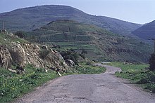
The double hills (hence the plural 'Tulūl', actually Dual Tallān instead of Singular Tell or Tall ) lie in the river valley of the Nahr ez-Zarqa , the biblical Jabbok, at the mouth of the Wadi Hajjaj coming from the south. Two twin-like, ruins-bearing natural hills, each 120 meters above the river bed, force the Zarqa River to follow a winding course. Until the 20th century, the twin hills blocked the way to the east in the valley of the ez-Zarqa. Ancient hikers had to switch to Wadi Hajjaj, which was the shortest route to the Ammonite settlement area . In this way, the Tulul adh-Dhahab were of great strategic importance until the construction of the Roman road at the exit of the Zarqa Valley to the Jordan Valley at today's Abu Zighan. Only about 6.5 kilometers west of the Tulul adh-Dhahab is the large Tell Deir 'Alla, which dates back to the Bronze and Iron Ages .
discovery
Research in the late 19th and 20th centuries was drawn to the attention of the descriptions of the Tulul adh-Dhahab by S. Merrill (1878, 1881), Gustaf Dalman , C. Steuerungagel, and others. M. Noth carried out topographical investigations in 1955. It was not until the American archaeologists Robert L. Gordon and Linda E. Villiers carried out a major survey in 1980 and 1982 . They published the first plan of the ruins that were still visible at the time.
The excavations since 2005
A team from TU Dortmund under the direction of Prof. Dr. Thomas Pola has been investigating the western of the two hills more closely since 2005 in collaboration with the Jordan Department of Antiquities. A team from the University of Basel has been involved in the excavations since 2006 , which is responsible, among other things, for geomagnetic prospecting , total station 3D surveying, as well as the creation of close-range aerial photographs and their photogrammetric analysis . In addition to the work of RL Gordon from 1980/82, a detailed map of the entire excavation area is now available for the first time, in which the above-ground artifacts are also measured.
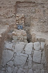
Three phases of settlement have so far been archaeologically proven on the two uppermost terraces of the hill. (I) The oldest settlement dates from between 1300 and 970 BC. Chr. (According to 14C data ); So far no associated building remains have been identified, but layers and finds. At least one of the predecessors of the fortification wall, which encloses terrace I and II, also belongs to this period. The stones with incised drawings used as building material in more recent architecture (II-III) could be from a cult or representative building from this oldest phase or a little later from the period 900 - 700 BC. Come from BC. The three larger and interpretable fragments found so far show (a) the head of a decorated lion, (b) a woman or a child with a goat, and (c) a stylistically related representation of two (seated?) Beardless people each holding an instrument clearly towering over their heads, possibly a harp. In addition, charcoals from the uppermost terrace date back to 1960–1750 BC. 14C-dated; However, these are currently isolated and their interpretation is unclear. - (II) So far, only small sections of the foundations of buildings on the uppermost terrace can be found that were built in the period 375-175 BC. And were laid down during the construction of the most recent phase. - (III) At last on the uppermost plateau there was a palace-like complex of about 30 × 30 m in size with two adjacent peristyle courtyards, each about 15 × 15 m in size, facing east. The architectural fragments of this palace are stylistically late Hellenistic or in the early years of Herod I (73-4 BC), coins and 14C dates substantiate this time approach. Detailed findings suggest that this architecture z. It was partly two-storey and adobe as well as stone were used as building material. This palace ended with a fire, presumably after approx. 50 - 25 BC. After that the complex was cleared and not used again. Later, what was still standing collapsed in an earthquake.
The two uppermost terraces are surrounded on the steep west, south and east slopes by a wall that is still around 0.5 - 1.5 m high today in longer sections. Room-like foundation trains are set on its inside. The relationship between layers and times of this city wall and the two consecutive palaces (II and III) has not yet been clarified. Further down, about halfway up, the investigations uncovered another, previously unknown, mighty weir system that cordoned off and protected the naturally more accessible north side of the approximately 120 m high hill.
In addition, at the southeast foot of the Tulul adh-Dhahab West, only a little above the Jabbok (Nahr az-Zarqa), but flood-proof, there is a Chalcolithic settlement, as a surface collection of mainly ceramics and silices shows.
ID
In research it is controversial with which ancient places the Tulul adh-Dhahab can be identified. Among other things, localities that are mentioned in the Old Testament (Pnuël / Penuel , Mahanaim) or the ancient historian Flavius Josephus ( Amathous , Essa) are discussed .
literature
- Boris Dreyer: Tulul adh-Dhahab (Wadi az-Zarqa) lead sling bullets from Terrace I. In: Annual of the Department of Antiquities of Jordan 57, 2013 (2016), ISSN 0449-1564, pp. 97-104.
- Robert L. Gordon, Linda E. Villiers: Telul edh Dhahab and its environs surveys of 1980 and 1982: a preliminary report. In: Annual of the Department of Antiquities of Jordan. Vol. 27, 1983, pp. 275-289.
- Robert L. Gordon: Telul edh Dhahab Survey (Jordan) 1980 and 1982. In: Communications of the German Orient Society in Berlin. Vol. 116, 1984, pp. 131-137.
- Martin Noth : The German Evangelical Institute for Classical Studies of the Holy Land. Teaching course 1955. In: Journal of the German Palestine Association. Vol. 72, 1956, ISSN 0012-1169 , pp. 31-82, here: pp. 52-58.
- Eveline Johanna van der Steen: Tribes and Territories In Transition. The central east Jordan valley and surrounding regions in the Late Bronze and Early Iron Ages: a study of the sources. Diss. Groningen 2002, pp. 187–188 ( PDF; 8.9 MB ).
- Thomas Pola , Mohammad al-Balawnah, Wolfgang Thiel, Emmanuel Rehfeld, Tobias Krause: Fragments of Carved Stones from Tulul adh-Dhahab in the Lower Wadi az-Zarqā. In: Journal of Epigraphy & Rock Drawings. Vol. 3, 2009 (2011), pp. 17-24.
- Thomas Pola, scratch drawings. Do archaeological finds from the East Bank shed light on Ez 8:10 and 1 Kings 6:29–36? In: Theological Contributions. 41, 2010, 97-113.
- Thomas Pola, Hannelore Kröger, Bernd Rasink, Jochen Reinhard, Mohammad al-Balawnah, Mohammad Abu Abila: A preliminary report of the Tulul adh-Dhahab (Wadi az-Zarqa) survey and excavation seasons 2005 - 2011. In: Annual of the Department of Antiquities of Jordan 57, 2013 (2016), ISSN 0449-1564, pp. 81-96 ( Link ).
- Jochen Reinhard: Things on strings and complex computer algorithms. Kite Aerial Photography and Structure from Motion Photogrammetry at the Tulul adh-Dhahab, Jordan. In: AARGnews 45, 2012, ISSN 1756-753X , pp. 37-41 ( Link or Link ).
- Thomas Pola, Pnuël / Pniël. In: www.wibilex.de: The scientific Bible dictionary on the Internet. ( Link ).
Web links
- Collection of 3D models of the topographical situation of the Tulul adh-Dhahab and their surroundings
- Homepage of the association "Archeology in the lower Jabboktal Jordan eV"
- Former official project homepage on the TU Dortmund University website ( Memento from March 10, 2012 in the Internet Archive )
- When Shoshenk chased Jeroboam. taz, August 18, 2005
- Report of the TU Dortmund on the 2006 excavation
- Jordan Times ( Memento June 17, 2011 in the Internet Archive ) (on the 2008 campaign)
- Björn Goldmann: Theologian digs and finds royal traces. WAZ, March 21, 2008
- Photo of a ceramic head
Individual evidence
- ↑ http://ochesnut.wordpress.com/tag/tulul-adh-dhahab/
- ^ Siegfried Mittmann: The Roman road in the north-western Belka. In: Journal of the German Palestine Association. Vol. 79, 1963, ISSN 0012-1169 , pp. 152-163.
- ↑ Department of Antiquities of Jordan ( Memento of the original from June 27, 2009 in the Internet Archive ) Info: The archive link was automatically inserted and not yet checked. Please check the original and archive link according to the instructions and then remove this notice.
- ↑ Thomas Pola, Hannelore Kröger, Bernd Rasink, Jochen Reinhard, Mohammad al-Balawnah, Mohammad Abu Abila: A preliminary report of the Tulul adh-Dhahab (Wadi az-Zarqa) survey and excavation seasons 2005 - 2011. In: Annual of the Department of Antiquities of Jordan 57, 2013 (2016), ISSN 0449-1564 , pp. 81-96 ( Link ).
- ↑ Boris Dreyer: Tulul adh-Dhahab (Wadi az-Zarqa) lead sling bullets from Terrace I. In: Annual of the Department of Antiquities of Jordan 57, 2013 (2016), ISSN 0449-1564 , pp. 97-104.
- ↑ Jochen Reinhard: Things on strings and complex computer algorithms. Kite Aerial Photography and Structure from Motion Photogrammetry at the Tulul adh-Dhahab, Jordan. In: AARGnews 45, 2012, ISSN 1756-753X , pp. 37-41 ( Link ).
- ↑ Jochen Reinhard: Structure-from-Motion-Photogrammetrie with Agisoft PhotoScan. First experiences from excavation practice . In: Undine Lieberwirth and Irmela Herzog (eds.), 3D applications in archeology. Computer applications and quantitative methods in archeology. Workshop of the AG CAA and the Cluster of Excellence Topoi 2013, Berlin . Edition Topoi, Berlin 2016, pp. 17–44 ( Link ).
- ↑ Frank Siegmund and Sandra Viehmeier: A previously unknown Chalcolithic settlement on the west hill of the Tulul adh-Dhahab, the Tall adh-Dhahab el-Gharbîyeh in the valley of the Nahr ez-Zarqa (Prov. Dscharasch, Jordan) . In: Christoph Rinne, Jochen Reinhard, Eva Roth Heege and Stefan Teuber (Eds.), From the soil find to the book - Archeology through the times. Festschrift for Andreas Heege. Historical Archeology Special Volume 1, Bonn 2017, pp. 39–49 ( PDF ).


