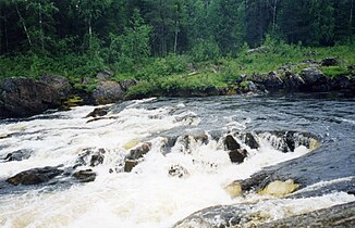
Tumcha
|
Tumcha Тумча, Тунтсайоки, Tuntsajoki |
||
| Data | ||
| Water code | FI : 73.09, RU : 02020000512102000000887 | |
| location |
Lapland ( Finland ), Murmansk Oblast , Republic of Karelia ( Russia ) |
|
| River system | Kowda | |
| Drain over | Kowda → White Sea | |
| source | in the Tuntsa wilderness area 67 ° 39 ′ 35 ″ N , 29 ° 34 ′ 10 ″ E |
|
| muzzle | in the lake Tumtschosero coordinates: 66 ° 40 '28 " N , 30 ° 40' 20" O 66 ° 40 '28 " N , 30 ° 40' 20" O
|
|
| length | 207 km (of which 172 km in Russia) | |
| Catchment area | 5240 km² | |
| Discharge at the gauge Alakurtti A Eo : 2100 km² Location: 67 km above the mouth |
MQ 1958/1988 Mq 1958/1988 |
27 m³ / s 12.9 l / (s km²) |
| Outflow location: 26 km above the mouth |
MQ |
51 m³ / s |
| Left tributaries | Vatsimanjoki | |
| Right tributaries | Kutsajoki | |
| Small towns | Alakurtti | |
The Tumcha ( Russian Тумча, Тунтсайоки ; Finnish Tuntsajoki ) is a river in Finland and Russia ( Murmansk Oblast and Republic of Karelia ).
The river emerges as Tuntsajoki in Tuntsa Wilderness Area ( Tuntsan Erämaa ) a few kilometers west of the Russian-Finnish border. From there it flows in a south-southeast direction and later crosses the border into Russia. He passes the small town of Alakurtti . The Kutsajoki , coming from the west, empties into the river about 16 km before it flows into the Tumchosero . The Tumtscha used to flow through the Tumtschosero . Since the 1960s, the Kowda downflow has been dammed at the Iowsk hydropower station , so that a lake landscape has formed, which also includes the Tumtschosero. From this point at the latest, the river is called the Tumtscha . In the last kilometers of its river, the Tumcha crosses the border with the Republic of Karelia. The catchment area covers 5240 km². The total length of the river Tuntsajoki and Tumcha is 207 km.
The river is fed by snowmelt and precipitation . The mean discharge 26 km above the mouth is 51 m³ / s. At the end of October / November the river freezes and remains ice-covered until May.
Web links
Individual evidence
- ↑ a b c d e f Article Tumtscha in the Great Soviet Encyclopedia (BSE) , 3rd edition 1969–1978 (Russian)
- ↑ a b Tumtscha in the State Water Register of the Russian Federation (Russian)
- ↑ Tumtscha at the Alakurtti gauge - hydrographic data from R-ArcticNET


