Tustna
| Tustna | ||||
|---|---|---|---|---|
|
||||
| Basic data | ||||
| Country | Norway | |||
| Province (fylke) | Møre and Romsdal | |||
| Municipality (commune) : | Aure | |||
| Coordinates : | 63 ° 11 ' N , 8 ° 3' E | |||
| Residents : | 1,006 (2004) | |||
| Area : | 139 km² | |||
| Population density : | 7.2 inhabitants per km² | |||
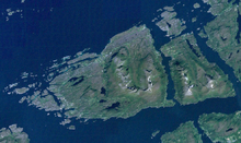
Tustna is an island , was an independent municipality from 1874 and has been a place in the Norwegian municipality of Aure in the Fylke (administrative district) Møre og Romsdal since January 1, 2006 . The administrative center of the municipality is Aure .
Before the amalgamation with Aure on January 1, 2006 after a resolution of June 24, 2004, the population of the former municipality of Tustna was 1,006 with an area of 139 square kilometers.
Since the end of 2006, Tustna has been connected to Aure by two bridges over the Sunde Imarsundet and Litjsundet . The NOK 185 million road section of the Rv 680 was built by Bilfinger Berger AG. The "Imarsund Bridge" is a 550 m long steel composite bridge. Three of the four pillars in the water were founded on driven steel piles in a water depth of up to 40 m. The "Litjsund Bridge" is a 300 m long prestressed concrete bridge with a main span of 160 m. It was built using the cantilever method.
Attractions
The Kråksundet Notnaust og Sjøbruksmuseum is a boathouse and fishing equipment museum . It is located on the island of Tustna in Kråksundet near Golma . In the old fishermen's houses , which were built around 1900, around 450 fishing objects and boats such as the Nordmørsgeita, the "Nordmørs goat", are on display.


