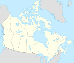
Two Mile Village
| Two Mile Village | ||
|---|---|---|
| Location in Yukon | ||
|
|
||
| State : |
|
|
| Territory : | Yukon | |
| Coordinates : | 60 ° 8 ′ N , 128 ° 50 ′ W | |
| Area : | 3.56 km² | |
| Residents : | 88 (as of 2006) | |
| Population density : | 24.7 inhabitants / km² | |
Two Mile Village is a place in the Canadian Yukon northwest of Watson Lake .
In 2006 it had 88 inhabitants who lived in an area of 3.56 km². The place is on the Robert Campbell Highway , which connects Watson Lake with Ross River , from where it continues to Carmacks . The next location is Two and One-Half Mile Village . Two Mile Village is only one kilometer north of Watson Lake Airport , which is located directly on the lake that gives it its name .
The residents belong to the Liard First Nation . This group, which also lives around Two and One-Half Mile Village , had a total of 1072 people in January 2009. Their language is the Kaska , which belongs to the Athabaskan language family , whereby it is closely related to the Talhtan , Sekani , Beaver , Slavey and the northern and southern Tutchone .
The 88 inhabitants (2006) of the "Indian settlement" lived in 40 households or belonged to 25 families. Of them, 85 spoke only English. Of these, 50 were men and 35 women. In 2001 the place only had 61 inhabitants. Almost a quarter of the residents were younger than 15 years.
Web links
- Kaska Language website
- Two Mile Village, Yukon Territory , City-data.com (part of Advameg, Inc. from Illinois)
Remarks
- ↑ According to information from the Department of Indian Affairs and Northern Development , Liard First Nation, Registered Population ( memento of the original from July 6, 2011 in the Internet Archive ) Info: The archive link was automatically inserted and not yet checked. Please check the original and archive link according to the instructions and then remove this notice.
- ^ Statistics Canada
