Union Bay (Seattle)
| Union Bay | ||
|---|---|---|
|
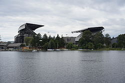
Union Bay from the Union Bay Natural Area with Laurelhurst, Evergreen Point Floating Bridge and Madison Park (from left to right) in the background |
||
| Waters | Lake Washington | |
| Land mass | North America | |
| Geographical location | 47 ° 39 '0 " N , 122 ° 17' 24" W | |
|
|
||
| width | about 1.7 km | |
| depth | about 1.7 km | |
| Islands | Marsh Island, Foster Island | |
| Tributaries | Arboretum Creek, Ravenna Creek | |
|
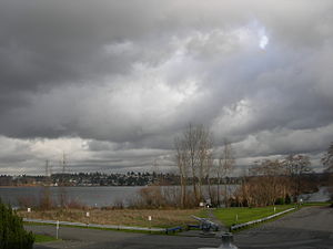
View in winter across Union Bay from the former Museum of History & Industry (MOHAI) building to Laurelhurst |
||

The Union Bay is a bay in Lake Washington in the city of Seattle in the State of Washington . The bay is bounded by the Laurelhurst neighborhoods to the north and Montlake and Madison Park to the south. The Evergreen Point Floating Bridge with Washington State Route 520 crosses part of the bay.
The islands of Marsh Island and Foster Island are located in Union Bay and are connected to the mainland (and each other) by the Arboretum Waterfront Trail and the Foster Island Trail. Union Bay ends at the eastern opening of Montlake Cut , which connects it to Portage Bay (an arm of Lake Union ) in the west - this marks the beginning of the Lake Washington Ship Canal , which runs through Seattle and Lake Washington with the Puget Sound connects.
history
When the water level of Lake Washington was lowered by almost 9 ft (3 m) in 1916 in the course of the opening of the Lake Washington Ship Canal, a good part of Union Bay and the adjacent marshland and wetland fell dry , which was due to embankments and subsequent orderly Landfill was promoted. The marsh and much of the bay were replenished between 1911 and 1967. The Montlake Landfill (in use from 1926 to 1967) was the fictional home of the television clown JP Patches , who lived there from 1958 to 1981. a The mall University Village (1956) and most of the eastern campus of the University of Washington (UW) in addition to the Husky Stadium are now in this country. What was left of the march on Union Bay is the renatured remnant in the Union Bay Natural Area of the UW.
On the one hand, the outflow of Lake Washington is at Union Bay, on the other hand it receives inflow from Arboretum Creek and Ravenna Creek via a pipeline from Ravenna Park, which runs through the south of the Ravenna district and to a disclosure in the renatured Union Bay Natural Area follows.
The shores of what is now Union Bay have been populated since the end of the last Ice Age around 10,000 years ago. Ancestors of today's Duwamish - Indians ( D kh w 'Duw'Absh , "the people from the inside" [the country] to the Lushootseed Coast Salish peoples belonging) villages inhabited until the 1850s around the bay.
The village of the hehs-KWEE-kweel ("rays") lay on the hloo-weelh-AHBSH (from s'hloo-WEELH , "a narrow hole drilled to measure the thickness of a canoe") was on the narrow passage the then advanced resource-rich march on Union Bay. Traces of the marsh have survived as the Union Bay Natural Area and as the Foster Island of the northern Washington Park Arboretum. The trees on the island of Stitici (pronounced like Stie-tie-tschie; "small island") were the place for their funeral ceremonies. Stitici is now called Foster Island. The village formed the north-eastern tip of what is now Madison Park. One of the Indian longhouses (pioneering cohousing for dozens of people) may have served as a potlatch house. The Duwamish are leveraging the holy site today in their pursuit of recognition as they are on the stretch of a massive extension of Washington State Route 520 through south Union Bay between Redmond and Interstate 5 . The prominent village of SWAH-tsoo-gweel ("Transport") was on a much larger Union Bay and today's Ravenna district was their backyard before the arrival of the Europeans, Laurelhurst in summer.
The Seattle, Lake Shore and Eastern Railway was built around 1886 along what is now the Burke-Gilman Trail . The route followed the Damiligen Ufer, on which the UW power station and the University Village district are today. At the site of today's power station there was a longhouse (on Montlake Boulevard across from the IMA building), others were on the north bank, which was then about a mile (1.6 km) further away, and on the bank east of what is now Union Bay Natural Area. In between, at what is now the Center for Urban Horticulture and Children's Hospital , there were one or two other longhouses. The villages were rather scattered settlements.
Cheshiahud (or "Lake John") and his family were among the people on Union Bay in the early decades of Seattle that are still remembered today.
Web links
- Union Bay Natural Area - Official Website
- Seattle Photographs Collection - University of Washington Library (English)
Individual evidence
- ↑ Phelps, US Army Corps of Engineers project 1913-1916, pp. 67-69
- ^ A b Myra L. Phelps: Public works in Seattle . Seattle Engineering Department, Seattle 1978, ISBN 0-9601928-1-6 , pp. 208, 210.
- ↑ a b HISTORY @ UBNA . Center for Urban Horticulture, Departments, University of Washington. Archived from the original on May 17, 2006. Info: The archive link was automatically inserted and not yet checked. Please check the original and archive link according to the instructions and then remove this notice. Retrieved April 21, 2006.
- ^ Alan J. Stein: Patches, Julius Pierpont . HistoryLink . March 2, 2003. Retrieved April 21, 2006.
- ↑ Ravenna . In: Seattle City Clerk's Neighborhood Map Atlas . Office of the Seattle City Clerk. not dated, with card dated June 17, 2002. Retrieved April 21, 2006.
- ↑ “University District”, map . Office of the Seattle City Clerk. not dated, with card dated June 13, 2002. Archived from the original on November 7, 2006. Info: The archive link was inserted automatically and has not yet been checked. Please check the original and archive link according to the instructions and then remove this notice. Retrieved April 21, 2006.
- ↑ Thomas Speer quoted in Switzer
- ↑ Jeff Switzer: Duwamish Tribe seeks protection for Foster Island , King County Journal. February 20, 2005. Accessed on July 21, 2006. ( Page no longer available , search in web archives ) Info: The link was automatically marked as defective. Please check the link according to the instructions and then remove this notice.
- ^ A b Tom Dailey: Duwamish-Seattle . In: Coast Salish Villages of Puget Sound . n. d .. Retrieved April 21, 2006.
- ↑ Junius Rochester: Seattle Neighborhoods: Laurelhurst - Thumbnail History . In: HistoryLink.org essay 3345 . June 2001. Retrieved April 21, 2006.
swell
- Higman, Harry Wentworth. Union Bay, the life city. Seattle, University of Washington Press, 1951. Print.
- Waterman, TT (n.d.) Puget Sound Geography. Washington, National Anthropological Archives, DC
- Duwamish et al. vs. United States of America (1927) US Court of Claims, Washington DC 1927, F-275.
- Buerge, David. Indian Lake Washington. Seattle Weekly , Jan. 1-7 August 1984.
- Buerge, David. Seattle Before Seattle. Seattle Weekly , March 17-23 December 1980.
- Smith, Marian W. (1940) The Puyallup-Nisqually. Columbia University Press, New York.
- "Ravenna" . (undated) Seattle City Clerk's Neighborhood Map Atlas (June 17, 2002). Retrieved April 21, 2006.
- Barrett, Christine. (1981, revised 1989) A History of Laurelhurst. Laurelhurst Community Club, Seattle.
- Dorpat, Paul. (1984 & 1989) Seattle: Now & Then, Vol. II and III Tartu Publications, Seattle.
- Saunders McDonald, Lucile. (1979) The Lake Washington Story. Superior Publishing Co., Seattle.
- Morgan, Brandt. (1979) Enjoying Seattle's Parks. Greenwood Publications, Seattle.
- Higman, Harry W. and Earl J. Larrison (1951) Union Bay: The Life of a City Marsh. University of Washington Press, Seattle.
- Sayre, James Willis. (1936) This City of Ours. Seattle School District No. 1, Seattle.
- Frye Bass, Sophie. (1937) Pig-Tail Days in Old Seattle. Binfords & Mort, Portland, OR.
- Sale, Roger. (1976) Seattle: Past to Present. University of Washington Press, Seattle.
- Broom, Jack. (1993) The JP Generation, In: Pacific Magazine , The Seattle Times . April 4, 1993, pp. 6-11, 14-17
- Cartmel, Bill. (1971) Hi Ya, Patches Pals. In: Seattle Post-Intelligencer , April 11, 1971, pp. 6-7
- Lacitis, Erik. (1978) Patches Understandings - and Survives. In: The Seattle Times , February 23, 1978, p. A15
- The East Side Journal , May 31, 1962, p. 3
- Ibid. May 14, 1969, p. 19.
- "University District" . Seattle City Clerk's Neighborhood Map Atlas (n.d., Fig. June 13), accessed April 21, 2006.


