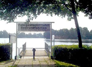
Bantikower See
| Bantikower See | ||
|---|---|---|

|
||
| Bantikower See with Unterseinsel | ||
| Geographical location | Ostprignitz-Ruppin district | |
| Tributaries | Klempnitz, Siepgraben | |
| Drain | Plumber | |
| Islands | Submarine island | |
| Location close to the shore | Kyritz | |
| Data | ||
| Coordinates | 52 ° 56 '0 " N , 12 ° 26' 45" E | |
|
|
||
| Altitude above sea level | 35.5 m | |
The Bantikower See , now also known as Untersee , is a channel lake in the Ostprignitz-Ruppin district , Brandenburg . The lake extends from the Kyritz residential area Stolpe in the north via Bantikow to Wusterhausen / Dosse in the south. Its length is about 7.5 kilometers with a width between 200 and 400 meters. Its greatest depth is east of the submarine island and is said to be 20 meters. The water surface is around 35.5 meters above sea level.
The lake belongs to the Kyritz chain of lakes in the Dosse lowlands . The southern part of the Bantikower See is called Klempowsee . The Kyritzer Seenkette with the Bantikower See is traversed by the Klempnitz .
history
The town of Kyritz bought Lake Stolpe, Bantikowschen and Königsbergschen from Margrave Johann for 180 silver marks in 1316.
In the past, "a wide and long bridge" was built between Bantikow and Stolpe, which was also called the "Langebrükke", to bring the cattle into the Stolpische Feldmark. This bridge no longer exists.
Web links
- Article on the history of the lake ( memento from February 17, 2013 in the web archive archive.today ) in the Märkische Allgemeine Zeitung
- Legend about the Bantikower See in the Märkische Allgemeine Zeitung
Individual evidence
- ↑ a b c Silver money for chain of lakes. Kyritzer paid 1316 cash and have since built close to the water. Märkische Verlags- und Druck-Gesellschaft mbH, August 10, 2002, archived from the original on February 17, 2013 ; Retrieved January 12, 2013 .

