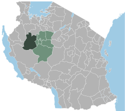
Urambo
| Urambo | |
|---|---|
 |
|
| Basic data | |
| Country | Tanzania |
| Capital | Urambo |
| surface | 75,264 km² |
| Residents | 370,796 (2002) |
| density | 4.9 inhabitants per km² |
| ISO 3166-2 | TZ-24 |
Coordinates: 5 ° 4 ′ S , 32 ° 4 ′ E
Urambo is a district in the Tabora region in Tanzania . The district is bounded in the north by the Shinyanga region , in the east by the Uyui district , in the southeast by the Sikonge district , in the southwest by the Rukwa region and in the west by the Kigoma region . The administrative seat is Urambo .
Urambo is located in the west of the Tabora region. Even today, the administrative headquarters can only be reached by unpaved roads. The nearest railway connection is in the city of Tabora .
The name comes from the area around the settlement of the people of Urambo Nyamwesi back to where the London Missionary Society , a mission founded in 1898 by the Moravian Church was acquired (Moravian Church) and exists to this day.
According to the census (Tanzania National Census) in 2002, the population was 370,796 people.
Wards
The Urambo district is divided into 26 regional administrative units ( wards ):
|
|
|
Individual evidence
- ↑ 2002 census in Tanzania ( Memento of the original from December 26, 2003 in the Internet Archive ) Info: The archive link was inserted automatically and has not yet been checked. Please check the original and archive link according to the instructions and then remove this notice. Urambo district in the Tabora region, subdivided into 26 wards