Original
|
Urspelt ( German ) Ischpelt ( lux. ) Urspelt ( French ) City of Clervaux
|
||
|---|---|---|
| Coordinates : | 50 ° 4 ' N , 6 ° 3' E | |
| Residents : | 138 (Jan 2, 2019) | |
| Postal code : | 9774 | |
|
Location of Urspelt in Luxembourg
|
||
|
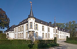
Urspelt Castle
|
||
Urspelt ( Luxembourgish Ischpelt ) is a district of Clervaux , canton Clervaux , in the Grand Duchy of Luxembourg .
location
Urspelt is in the Ösling in the east of Luxembourg. On the eastern edge of the village, the Irbich flows past the place. The CR 340 and CR 339 run through the town. Neighboring towns are Hüpperdingen and Grindhausen in the north, Fischbach in the east and Reuler in the south .
General
Urspelt is a rural village. The center of the town is the Urspelt Castle , built in 1860, and the baroque Antonius Chapel .
Web links
Commons : Urspelt - collection of images, videos and audio files
Individual evidence
- ↑ Statistiques sur la population - population statistics. In: Website of the city of Clervaux. Retrieved May 21, 2019 .


