Uvinza (district)
| Uvinza district | |
|---|---|
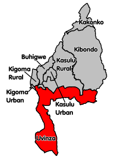
 Location of the Uvinza district in Tanzania |
|
| Basic data | |
| Country | Tanzania |
| region | Kigoma |
| surface | 10,058 km² |
| Residents | 383,640 (2012) |
| density | 38 inhabitants per km² |
| ISO 3166-2 | TZ-08 |
Coordinates: 5 ° 5 ′ S , 30 ° 14 ′ E
Uvinza is a district in the Tanzanian region of Kigoma with the capital Uvinza . The district is bordered by the Kigoma , Kasulu and Kibondo districts to the north, the Tabora region to the east, the Katavi region to the southeast and the Democratic Republic of the Congo to the west .
geography
Uvinza is 10,058 square kilometers and has around 380,000 inhabitants (as of 2012). The district is east of Lake Tanganyika . From its shore, which is 800 meters above sea level, the land rises steeply to up to 1750 meters. There is a hilly plateau that is drained by the Malagarasi and Lugufu rivers. The valleys are located at around 1000 meters above sea level, the rivers flow in marshy deltas into Lake Tanganyika.
The climate in the district is tropical, Aw according to the effective climate classification . An annual average of around 1000 millimeters of rain falls, the average annual temperature is 22.5 degrees Celsius.
history
Uvinza District was established in 2011 by splitting off from Kigoma District.
Administrative division
Uvinza is divided into 14 parishes (wards):
- Kalya
- Buhingu
- Igalula
- Sigunga
- Sunuka
- Ilagala
- Simbo
- Kandaga
- Kazuramimba
- Uvinza
- Mganza
- Mtego wa Noti
- Nguruka
- Itebula
populationThe population in the district rose by more than a third from 284,644 in 2002 to 383,640 in 2012. Of those over five years of age, 58 percent could read and write Swahili, 5 percent English and Swahili, 37 percent were illiterate (as of 2012). Facilities and services |
 |
- Education: 28 percent of those over five were currently attending school, 12 percent had dropped out of school, 31 percent finished school and 29 percent had never attended school (as of 2012).
- Health: In 2012, six percent of the population had social security.
- Water: In 2016, 44 percent of the population had access to safe and clean water.
Economy and InfrastructureThe most important branch of the economy is agriculture, it contributes over ninety percent to the district income.
|
 |
- Railway: The Tanganyika Railway from Dar es Salaam to Kigoma runs through the district capital Uvinza. The railway was built as a 1000 millimeter narrow-gauge railway, it will be expanded from east to west to standard gauge (as of 2018).
- Road: A national road runs largely parallel to the railway line from east to west through the district. In the city of Uvinza, the T9 national road branches off southwards towards Mpanda .
Attractions
- Mahale Mountains National Park : The 1613 square kilometer montane rainforest contains 73 species of mammals, nine species of primate, including a chimpanzee population.
- Lake Tanganyika: With a length of 660 kilometers, the lake is the longest and, with a depth of 1,436 meters, the second deepest lake on earth. It is also known for its large variety of brightly colored cichlids .
Web links
Individual evidence
- ↑ Statistics | UVINZA DISTRICT COUNCIL. Retrieved December 16, 2019 (Swahili).
- ^ Tanzania Regional Profiles, 16 Kigoma Regional Profiles. (pdf) The United Republic of Tanzania, 2016, p. 17 , accessed on December 16, 2019 .
- ^ Kigoma Region, Socio-Economic Profile. (pdf) The United Republic of Tanzania, December 1998, pp. 2–5 , accessed on December 16, 2019 .
- ^ Uvinza climate: Average Temperature, weather by month, Uvinza weather averages - Climate-Data.org. Retrieved December 16, 2019 .
- ↑ History | UVINZA DISTRICT COUNCIL. Retrieved December 16, 2019 (Swahili).
- ↑ 2012 Population and Housing Census. (pdf) National Bureau of Statistics and Ministry of Finance, March 2013, p. 151 , accessed on December 16, 2019 .
- ^ Tanzania Regional Profiles, 16 Kigoma Regional Profiles. (pdf) The United Republic of Tanzania, 2016, pp. 16, 72 , accessed on December 16, 2019 .
- ^ Tanzania Regional Profiles, 16 Kigoma Regional Profiles. (pdf) The United Republic of Tanzania, 2016, p. 79 , accessed on December 16, 2019 .
- ^ Tanzania Regional Profiles, 16 Kigoma Regional Profiles. (pdf) The United Republic of Tanzania, 2016, p. 126 , accessed on December 16, 2019 .
- ↑ Water | UVINZA DISTRICT COUNCIL. Retrieved December 16, 2019 (Swahili).
- ^ Agriculture | UVINZA DISTRICT COUNCIL. Retrieved December 16, 2019 .
- ^ Tanzania Regional Profiles, 16 Kigoma Regional Profiles. (pdf) The United Republic of Tanzania, 2016, pp. 129, 131 , accessed on December 16, 2019 .
- ↑ Livestock & Fishing | UVINZA DISTRICT COUNCIL. Retrieved December 16, 2019 .
- ^ Modal Choice between Rail and Road Transportation, Evidence from Tanzania. World Bank Group, August 2017, pp. 7–8 , accessed November 3, 2019 .
- ↑ National Five Years Development Plan 2016/17 - 2020/21. (pdf) Ministry of Finance and Planning, June 2016, p. 19 , accessed on December 16, 2019 .
- ^ Tanzania Trunk Road Network. Retrieved November 16, 2019 .
- ↑ Tanzania in Figures, 2018. (pdf) National Bureau of Statistics, June 2019, p. 8 , accessed December 16, 2019 .
- ^ Mahale Mountains National Park. Retrieved November 4, 2019 .
- ↑ Lake Tanganyika. Encyclopaedia Britannica, accessed November 4, 2019 .
- ↑ Lake Tanganyika Cichlids. Retrieved November 4, 2019 .


