
Veleslavín
| Veleslavín | |||
|---|---|---|---|
|
|||
| Basic data | |||
| State : |
|
||
| Region : | Hlavní město Praha | ||
| Municipality : | Praha | ||
| Administrative district : | Prague 6 | ||
| Area : | 113 ha | ||
| Geographic location : | 50 ° 5 ' N , 14 ° 20' E | ||
| Residents : | 6,326 (December 31, 2015) | ||
| Postal code : | 162 00 | ||


Veleslavín (German Weleslawin ) is a district of the Czech capital Prague . It lies to the east over the valley of the Litovický potok .
history
The village first appeared in the annals under Boleslav II , who gave it to the Břevnov Monastery . At the request of Maria Theresa , a small castle was built in the village, designed by Kilian Ignaz Dientzenhofer . The Prussian King Friedrich chose this little castle as his command center during the siege of Prague.
Veleslavín, which emerged from the villages of Starý Veleslavín (Altweleslawin) and Nový Veleslavín (New Weleslawin), was annexed to Prague in 1922. It formed the former Prague XIX district, today it is part of Prague 6 . In 1991 the place had 6,032 inhabitants. In 2001 Veleslavín consisted of 420 houses in which 6137 people lived.
sons and daughters of the town
- Daniel Adam z Veleslavína , writer of humanism in Bohemia
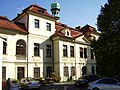
Veleslavín Castle

Residential complex Hvězda

Praha Veleslavín train station


