
Administrative community Pegau
| coat of arms | Germany map | |
|---|---|---|

|
Coordinates: 51 ° 10 ′ N , 12 ° 15 ′ E |
|
| Basic data | ||
| State : | Saxony | |
| County : | Leipzig | |
| Area : | 60.45 km 2 | |
| Residents: | 7616 (Dec. 31, 2019) | |
| Population density : | 126 inhabitants per km 2 | |
| License plate : | L , BNA, GHA, GRM, MTL, WUR | |
| Association key : | 14 7 29 5308 | |
| Association structure: | 2 municipalities | |
| Association administration address : |
Markt 1 04523 Pegau |
|
| Website : | ||
| Administrative Chairman: | Peter Bringer | |
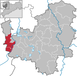
| Location of the Pegau administrative community in the Leipzig district | ||
  |
||

The Pegau administrative association is an administrative association in the Free State of Saxony in the Leipzig district . It is located in the west of the district, around 25 km south of the city of Leipzig and around 18 km west of the district town of Borna on the border with Saxony-Anhalt . The newly developed Leipziger Neuseenland is to the east of the municipality . The Federal Highway 2 runs through the Community. The Leipzig – Zeitz railway also runs through the community. The White Elster flows through the community area in a north-south direction.
The municipalities with their districts
Municipality of Pegau with the districts Pegau , Carsdorf , Wiederau , Großstorkwitz, Maschwitz , Weideroda, Zauschwitz , Kitzen , Hohenlohe , Eisdorf, Thesau, Sittel, Scheidens, Peißen , Löben , Seegel , Werben , (Schkorlopp), Großschkorlopp , Kleinschkorlopp .
Elstertrebnitz community with the districts of Eulau, Elstertrebnitz, Tannewitz, Trautzschen, Greitschütz, Costewitz and Oderwitz
Individual evidence