
Administrative community Thannhausen
| coat of arms | Germany map | |
|---|---|---|
|
|
Coordinates: 48 ° 17 ' N , 10 ° 28' E |
|
| Basic data | ||
| State : | Bavaria | |
| Administrative region : | Swabia | |
| County : | Gunzburg | |
| Area : | 53.14 km 2 | |
| Residents: | 9422 (Dec. 31, 2019) | |
| Population density : | 177 inhabitants per km 2 | |
| License plate : | GZ, KRU | |
| Association key : | 09 7 74 5732 | |
| Association structure: | 3 municipalities | |
| Association administration address : |
Christoph-v.-Schmid-Str. 7 86470 Thannhausen |
|
| Website : | ||
| Community Chairman : | Georg Schwarz ( CSU / FW ) | |
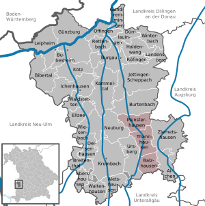
| Location of the administrative community Thannhausen in the district of Günzburg | ||
  |
||

The administrative community of Thannhausen is located in the Swabian district of Günzburg and is formed by the following communities:
- Balzhausen , 1200 inhabitants, 14.63 km²
- Münsterhausen , Markt , 1972 inhabitants, 18.48 km²
- Thannhausen , city with 6250 inhabitants, 20.03 km²
The administrative association is based in Thannhausen.

The administrative community also originally included the municipality of Ursberg (until October 3, 1978: Bayersried-Ursbeg ), which was dismissed with effect from January 1, 1980 and has managed itself since then.
Individual evidence
- ↑ "Data 2" sheet, Statistical Report A1200C 202041 Population of the municipalities, districts and administrative districts 1st quarter 2020 (population based on the 2011 census) ( help ).
- ^ Official register of places for Bavaria, territorial status: May 1, 1978, issue 380 of the contributions to the statistics of Bavaria
- ↑ Law on the change in the membership of municipalities in administrative communities of 10 August 1979 ( GVBl p. 223)
Administrative communities in the Günzburg district