
Administrative community Thurmansbang
| coat of arms | Germany map | |
|---|---|---|
 Help on coat of arms |
Coordinates: 48 ° 46 ' N , 13 ° 19' E |
|
| Basic data | ||
| State : | Bavaria | |
| Administrative region : | Lower Bavaria | |
| County : | Freyung-Grafenau | |
| Area : | 55.17 km 2 | |
| Residents: | 3580 (Dec. 31, 2019) | |
| Population density : | 65 inhabitants per km 2 | |
| License plate : | FRG, GRA, WOS | |
| Association key : | 09 2 72 5213 | |
| Association structure: | 2 municipalities | |
| Association administration address : |
Gründelln 3 94169 Thurmansbang |
|
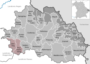
| Location of the administrative community Thurmansbang in the Freyung-Grafenau district | ||
  |
||

The administrative community Thurmansbang is located in the Lower Bavarian district of Freyung-Grafenau and has been formed by the following communities since May 1, 1978:
- Thurmansbang , 2,435 inhabitants, 32.92 km²
- Zenting , 1145 inhabitants, 22.25 km²
The administrative community is based in Thurmansbang. In 2013, the Zentings area was enlarged by a piece of the community-free Sonnenwald area.
From its founding on May 1, 1978 to December 31, 1979, the administrative community also included the municipality of Saldenburg .
Individual evidence
- ↑ "Data 2" sheet, Statistical Report A1200C 202041 Population of the municipalities, districts and administrative districts 1st quarter 2020 (population based on the 2011 census) ( help ).
- ↑ Dismissal by law of August 10, 1979 (GVBl p. 223)
Administrative communities in the Freyung-Grafenau district
Hinterschmiding | Perlesreut | Schoenberg | Thurmansbang
Dissolved: Sankt Oswald