
Viaduc des Rochers Noirs
Coordinates: 45 ° 16 ′ 6 ″ N , 2 ° 10 ′ 56 ″ E
| Viaduc des Rochers Noirs | ||
|---|---|---|
 |
||
| use | Former railway bridge, then road bridge, currently closed to all traffic | |
| Convicted | Railway line Tulle - Ussel | |
| Crossing of | The Luzège | |
| place | Lapleau - Soursac | |
| construction | Cable-stayed bridge | |
| overall length | 170 m | |
| Longest span | 140 m | |
| height | 45 m (pylon height) | |
| Clear height | 92 m | |
| opening | 1913 | |
| closure | 2005 | |
| location | ||
|
||

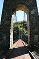
The Viaduct of the Black Rocks , French Viaduc des Rochers Noirs , has spanned the French river Luzège in the Corrèze department between the towns of Lapleau and Soursac for more than a hundred years . It was originally a railway bridge line Transcorrézien that of the former railway company Tramways de la Corrèze was operated.
history
The bridge was designed by Albert Gisclard (1844–1909), designed and built by Ferdinand Arnodin's company from 1911 to 1915. On August 1, 1913, the bridge was opened by then President Raymond Poincaré for the route from Tulle to Ussel . In 1959, the company stopped rail operations and the bridge was converted into a road bridge. From 1960 to 1983 it passed over the Départementale D89, after which it was a pure pedestrian bridge. Since December 6, 2000, it has been classified as a Historic Monument in France . From 2005 all traffic was banned for safety reasons.
gallery

Viaduc des Rochers Noirs

The bridge

Historic monument
The blocked bridge


Web links
- Photos and information about the bridge - French
- Photos of the bridge - French
- Tourist information - French