
Victoria Falls Bridge


The Victoria Falls Bridge spans the Zambezi directly below the Victoria Falls . It was built over the second canyon of the falls. Since the river forms the border between Zimbabwe and Zambia here, the bridge connects the two countries and has border posts at both ends, at the cities of Victoria Falls in Zimbabwe and Livingstone in Zambia. Its largest span is 156.5 meters, its total length 198 meters and its height 128 meters.
history
The bridge is the brainchild of Cecil Rhodes and his unfulfilled large colonial project known as the Cape Cairo Plan , which also included a rail link from the South African Cape of Good Hope to Cairo in Egypt - even if he never visited the Victoria Falls and died before the bridge was built. Rhodes is reported to have instructed the engineers, “. .to build the bridge over the Zambezi where the trains catch the drizzle of the falls as they pass ”. The bridge was designed in the Sir Douglas & Francis Fox engineering firm in London by George Anthony Hobson and Ralph Freeman , the engineer who later worked on the construction of the Sydney Harbor Bridge in Australia.
The bridge was built in England by Cleveland Bridge & Engineering Co. , then transported by ship to the port of Beira in Mozambique and transported to the falls on the newly built railway line also planned by Sir Douglas & Francis Fox. It took only 14 months to build and was completed in 1905.
It was officially opened on September 12, 1905 by Professor George Howard Darwin , the son of Charles Darwin . The American Society of Civil Engineers lists the bridge as an International Historic Civil Engineering Landmark .

Constructed of steel, the bridge is 198 meters long, with an arch span of 156.50 meters and a height of 128 meters above the low water mark of the river. Originally built as a double-track railway bridge, since reinforcement in 1929 it has led a road, a railway line and a footpath. The bridge is the only rail link between Zambia and Zimbabwe and one of only three road links between the two neighboring countries. The other two road links are the Chirundu Bridge and the Kariba Dam .
For more than 50 years, the Victoria Falls Bridge was regularly crossed by passenger trains as part of the main connection between what was then Northern Rhodesia (Zambia), South Africa and finally Europe. Freight trains mainly brought copper ore and timber from Zambia south.
The age of the bridge and maintenance problems eventually led to traffic restrictions. They have been banned from using trains and trucks weighing more than 30 tons since 2006.
During the Rhodesian War, the bridge was mostly closed and in 1975 the place of fruitless peace talks, during which the conflicting parties met for more than nine hours in a railway carriage on the bridge. In 1980, freight and passenger traffic was resumed and has been running without interruption since then - except for maintenance work. Originally the bridge was called the "Great Zambezi Bridge" or "Zambezi Bridge", only later it was named Victoria Falls Bridge.
gallery

Seen from the Zambian side

Helicopter view
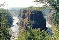
Zambezi Gorges below Victoria Falls with Victoria Falls Bridge in the background
.jpg)


Web links
swell
- ↑ Victoria Falls Bridge. In: Structurae
- ↑ http://www.sunsteelandspray.com/pages/bridgingthezambezi.html
- ↑ a b Hyder Consulting: Footprints on a global landscape - 150 years of improving the built environment ( Memento from November 24, 2013 in the Internet Archive ) (PDF; 4.3 MB)
- ↑ http://www.tothevictoriafalls.com/vfpages/devel/bridge.html Page: To The Victoria Falls
- ↑ American Society of Civil Engineers: Victoria Falls Bridge. (English), accessed on May 21, 2019
- ↑ The Building of Victoria Falls Bridge on zambiatourism.com.Retrieved November 23, 2015
- ↑ BBC News On This Day: August 26 , "1975: Rhodesia peace talks fail" . Retrieved March 3, 2012, with video clip.
Coordinates: 17 ° 55 ′ 42.2 ″ S , 25 ° 51 ′ 26.1 ″ E