
Volksgarten district
| Basic data | |
|---|---|
| State : | Upper Austria |
| Political District : | Linz ( L ) |
| Area : | 1.08 km² |
| Geographic location : | still missing |
| Height : | 266 m above sea level NN |
| Residents : | 5,994 (as of Jan. 1, 2006) |
| Postal code : | 4020 |
| Area code : | 0732 |

The Volksgartenviertel is located in downtown Linz and was a separate statistical district of the city of Linz from 1957 to 2013.
geography
The quarter is bordered to the north by Stiftergasse not far from the New Cathedral , to the east by Landstrasse , to the south by the main train station and to the west by Roseggerstrasse and the Gugl .
Neighboring districts
The neighboring districts are the Altstadtviertel in the north, the Neustadtviertel in the east, the Andreas-Hofer-Platz -viertel in the south and Froschberg in the west.
useful information
Aside from the shopping facilities and the local transport hub at the main train station, the district has several parks and green spaces, such as the Volksgarten on Landstrasse.
Important buildings and parks
- Bergschlössl
- Central Station
- State service center
- Headquarters of the Chamber of Labor Upper Austria
- Knowledge tower
- Terminal Tower
- Power Tower
- Volksgarten
- Schiller Park
District views
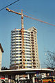
The “Knowledge Tower” near Linz Central Station a few months before its completion.

literature
- Franz Dobusch, Johann Mayr (Hrsg.): Linz - city of work and culture. Gutenberg-Werbering, Linz 1997.
- City research Linz: Linz 2000. Facts, pictures, graphics. CD-ROM. Linz 2000.
Individual evidence
- ^ Linz - Politics / Administration - Linz Figures - City Area (with an overview of the current and former statistical districts of Linz that were valid from 1957 to 2013).