Waldrennach
|
Waldrennach
community Neuenbuerg
|
|
|---|---|
| Coordinates: 48 ° 49 ′ 55 " N , 8 ° 36 ′ 33" E | |
| Height : | 553 (553-580) m |
| Area : | 5.69 km² |
| Residents : | 731 (Aug. 30, 2017) |
| Population density : | 129 inhabitants / km² |
| Incorporation : | 1st January 1975 |
| Postal code : | 75305 |
| Area code : | 07082 |
|
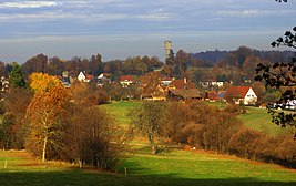
Waldrennach with water tower
|
|
Waldrennach is a village in the northern Black Forest and part of the community of Neuenbürg .
geography
The place is on a hillside between the Enz valley and the heights of the northern Black Forest. When the weather is clear, it is possible to see the Vosges or the cathedral in Speyer .
history
On January 1, 1975, Waldrennach was incorporated into Neuenbürg.
Worth seeing
The water tower, which can be climbed on request, is visible from afar and provides a panoramic view. The visitor mine Grube Frischglück shows interesting insights into the historical iron ore mining between 1770 and 1866.
Individual evidence
- ↑ General data ( Memento of the original from March 6, 2017 in the Internet Archive ) Info: The archive link has been inserted automatically and has not yet been checked. Please check the original and archive link according to the instructions and then remove this notice. at neuebuerg.de
- ^ Federal Statistical Office (ed.): Historical municipality directory for the Federal Republic of Germany. Name, border and key number changes in municipalities, counties and administrative districts from May 27, 1970 to December 31, 1982 . W. Kohlhammer, Stuttgart / Mainz 1983, ISBN 3-17-003263-1 , p. 490 .

