Forest ponds
| Forest ponds Alter pond, middle pond, Pochteich |
|||||||
|---|---|---|---|---|---|---|---|
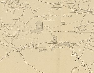
| The ponds on a map from 1868, pivoted 90 ° to the left | |||||||
|
|||||||
|
|
|||||||
| Coordinates | 50 ° 50 ′ 38 " N , 13 ° 20 ′ 37" E | ||||||
| Data on the structure | |||||||
| Lock type: | dam | ||||||
| Construction time: | before 1524 | ||||||
| Data on the reservoir | |||||||
| Water surface | 7.5 ha (total) | ||||||
| Storage space | 44,200 m³ (total) | ||||||
| Particularities: |
1840 dams cut through |
||||||
The forest ponds were three artificial ponds in the Freiwald between Großhartmannsdorf and Brand-Erbisdorf in Saxony . Established in the first half of the 16th century, they supplied mountain buildings in the southern Freiberg district with impact water until 1776 . The dammed flowing water was the Münzbach .
location
| Surname | Dimensions | surface | depth | volume | location |
|---|---|---|---|---|---|
| Old pond | 350 × 190 m | 4.5 ha | 4.6 m | 37,000 m³ | ⊙ |
| Middle pond | 220 × 120 m | 2.2 ha | 3.7 m | 11,500 m³ | ⊙ |
| Pochteich | 70-90 × 65 m | 0.8 ha | 2.8 m | 5,700 m³ | ⊙ |
The three ponds Alter Teich (also Wüster Teich ), Mittelteich ( Mittlerer Teich ) and Pochteich were in Niederfrei , the northeastern part of the Freiwald in the area of the Erbisdorf district. Only about 900 m after the source of the Münzbach, which was still called Waldflössel here in the 19th century, they immediately followed each other to about 500 to 505 m above sea level. NN . The old pond began about 100 m and only a few meters below the Kohlbach artificial ditch . Even then, a west-east running path led between the Altes Teich and Mittelteich, today's Alte Waldstraße. And immediately after the middle pond was the Pochteich, the smallest of the three ponds. Both are north-south oriented.
Only about 330 m behind the dam of the Pochteich follows the Erzengler Pond , which is also still in the Freiwald and was sometimes referred to as the fourth forest pond.
history
The ponds were probably created before 1524. Before 1570 , Martin Planer had two of the ponds "made good for the mine". Since they failed especially in dry seasons, a remedy was found around 1560 with the Kohlbach-Kunstgraben. In the old days there was another ditch here, which, a little below the Kohlbach artificial ditch, ran over the medieval old courtyard and ended in the ponds.
The impact water was used by the Sun and God's Gift , Old Murder Pit , Archangel , St. Stephan and Sonnenwirbel pits .
At the Pochteich there was a stamping mill that processed the ores from the nearby pits. Which is not known, but the pits Kurhaus Sachsen , Johannes , Freudenstein , Oberes Haus Sachsen , Neues Haus Sachsen and Silberschnur were built nearby . In 1776 the use was stopped. Later the pond areas were planted with spruce. In 1840 the dams were finally cut after the area was devastated by a flood from the Kohlbach artificial ditch.
literature
- Konrad Knebel : The Münzbachtal. Local history research . In: Messages from the Freiberg Antiquities Association . No. 44 , 1908, pp. 11–12 ( digitized version ).
- Wolfgang Jobst, Walter Schellhas : Abraham von Schönberg - life and work . The revival of mining in the Ore Mountains after the Thirty Years' War by chief miner von Schönberg. In: Freiberg research books . Reprint of the 1st edition. D 198. TU Bergakademie, Freiberg 2007, ISBN 978-3-86012-305-8 , p. 165 f .
Individual evidence
- ^ Otfried Wagenbreth , Eberhard Wächtler (ed.): The Freiberg mining industry . Technical monuments and history. 2nd Edition. German publishing house for basic industry, Leipzig 1988, ISBN 3-342-00117-8 , p. 65 .
- ↑ Richard Wengler: Report of the mountain manager Martin Planer on the state of Freiberg mining in 1570 . In: Messages from the Freiberg Antiquities Association . Issue 35 (1898), 1899, pp. 74 ( digitized version ).
- ^ A b Johann Friedrich Märker: Chronick, or topographical-historical description of the Erzgebirge town Groshartmannsdorf . 2nd Edition. Hofmann, Marienberg 1988, p. 65 ( digitized version ).
- ^ Karl Gautsch : The old castles and knight seats around Freiberg . The "old farm" in Nieder-Freiwalde near Erbisdorf. In: Communications from the Freiberg Antiquities Association . No. 15 , 1878, p. 1482 ( digitized version ).
- ↑ Council Forest Ponds (Ancient Forest Pond, Middle Pond Forest, Pochteich and Erzengler pond) in the lower Freiwald at Erbisdorf (inventory 40010, archive document 2989). Retrieved December 3, 2017 .

