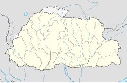
Wangdue Phodrang (locality)
| Wangdue Phodrang | ||
|---|---|---|
|
|
||
| Coordinates | 27 ° 29 ′ N , 89 ° 54 ′ E | |
| Basic data | ||
| Country | Bhutan | |
| Wangdue Phodrang | ||
| ISO 3166-2 | BT-24 | |
| Residents | 7507 (2017) | |
Wangdue Phodrang ( Dzongkha : དབང་ འདུས་ ཕོ་བྲང་ རྫོང་ ཁག་ ) is the main town of the Dzongkhag of the same name in western Bhutan .
Location and importance
The old town and the dzong are located on a narrow ridge above the Puna Tsang Chhu at an altitude of around 1250 m . This tributary of the Brahmaputra is crossed below the old town by the road from the direction of Thimphu , there is a checkpoint at the junction of the road to Sarpang .
With its 7507 inhabitants, the village is an important center of this part of the country is of economic importance in addition to agriculture, in particular the trade, through the role as a major transport hub on the Paro-Samdrupjongkhar Street as taught herein or around the Wangdue- Tsirang Road and the route to Khuruthang , Punakha and Gasa is promoted. The tourist infrastructure has been expanded in recent years, as there are numerous sights in and around Wangdue Phodrang.
| Wangdi Phodrang | ||||||||||||||||||||||||||||||||||||||||||||||||
|---|---|---|---|---|---|---|---|---|---|---|---|---|---|---|---|---|---|---|---|---|---|---|---|---|---|---|---|---|---|---|---|---|---|---|---|---|---|---|---|---|---|---|---|---|---|---|---|---|
| Climate diagram | ||||||||||||||||||||||||||||||||||||||||||||||||
| ||||||||||||||||||||||||||||||||||||||||||||||||
|
Monthly average temperatures and rainfall for Wangdi Phodrang
Source: WMO
|
|||||||||||||||||||||||||||||||||||||||||||||||||||||||||||||||||||||||||||||||||||||||||||||||||||||||||
history
Legend has it that the Shabdrung Ngawang Namgyel , while looking for a place to build a dzong to protect against invaders from the south, found a playing boy named Wangdi on the bank of the expanding Punak Dzang Chhu and built him on the mountain spur in 1638 Dzong named after this Wangdis palace.
The climatically favored place developed early on into a trading center at the foot of the road to Central Bhutan via the Pele La and the Lawa La , at the same time the Punak Dzang valley offered easy access to Assam .
At the beginning of the 21st century, increasing traffic forced the town to be partially relocated to a plain east of the river around four kilometers north of the Dzong. After prophecies for 2006 and 2007 predicted such a relocation as unfavorable, the relocation of the residential districts has meanwhile begun, but large parts of the infrastructure are still in the old town.
Web links
Individual evidence
- ↑ Population of Cities in (2017). World Population Review, accessed February 14, 2017 .


