Washington Lake
| Washington Lake | ||
|---|---|---|

|
||
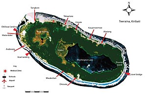
| Teraina Island with Washington Lake | ||
| Geographical location | in the southeast of the island of Teraina | |
| Tributaries | (Rainfalls) | |
| Drain | 2 channels | |
| Location close to the shore | Kauamwemwe | |
| Data | ||
| Coordinates | 4 ° 40 '49 " N , 160 ° 22' 8" W | |
|
|
||
| Altitude above sea level | 1 m | |
| surface | 2.79 km² | |
| length | 3.3 km | |
| width | 1.2 km | |
| volume | 4,200,000 m³ | |
| scope | 8.4 km | |
| Maximum depth | 10 m | |
| Middle deep | 1.5 m | |
|
particularities |
former lagoon |
|

|
||
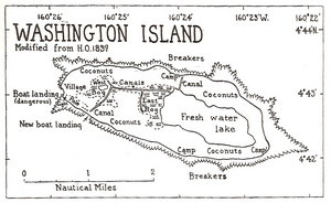
| Fresh water lake on the historical map | ||
Washington Lake , not to be confused with Lake Washington , is a more than 200 hectares large freshwater lake on the island Teraina (formerly Washington Iceland ) an upscale atoll in the northern Line Islands in the Pacific island nation of Kiribati . It originated from the former lagoon of the atoll .
Washington Lake is located in the eastern half of Teraina Island and extends over 3.3 kilometers in an east-west direction and is a maximum of 1200 meters wide. The lake is on average 1.5 meters deep and reaches a maximum depth of 10 meters. One of Teraina's two peat bogs, the East Bog, borders directly on the west bank . The West Bog is further west.
The lake is only fed by the abundant tropical rainfall averaging 2970 millimeters per year. Precipitation can double during El Niño . The drainage takes place via boat channels. A canal to the west connects the lake in the northwest via the East Bog and on to the West Bog to a second channel to the southwest, via which there is an adjustable discharge to the sea. The canals were built at the beginning of the 20th century to drain the moors and to transport copra .
Web links
- Teraina.com
- International Water Management Institute: Republic of Kiribati (PDF file; 229 kB)
