Washington State Route 16

|
|
|---|---|
| map | |

|
|
| Basic data | |
| Overall length: | 43.47 km, 27.01 miles |
| Opening: | 1964 |
| Starting point: |
|
| End point: |
|
| Counties: | Pierce County Kitsap County |
| Important cities: | Tacoma Gig Harbor Port Orchard |
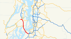
State Route 16 , commonly called Highway 16, is a 43.47 km long freeway in the US state of Washington , of the Interstate 5 and State Route 3 connects.
Route description
The State Route 16 begins at the Interstate 5 in Tacoma (exit 132, called Nalley Valley Interchange), from there to the north and crosses at milestone 5.62 the Tacoma Narrows Bridge to Gig Harbor Peninsula. From Interstate 5 to the Gig Harbor Olympic Drive Northwest exit, SR 16 offers a high-occupancy vehicle lane in both directions. The section between the Union Avenue exit and Interstate 5 is currently under construction. From Gig Harbor, SR16 continues towards Burley , Bethel and Port Orchard . The end point of SR16 is in Gorst , where SR 16 and Washington State Route 3 meet.
Motorway feeder
The 0.63 km (0.39 mile) motorway slip State Route 16 trail connects Washington State Route 3 and State Route 16th
List of exits and milestones
| county | place | milestone | exit | Directions | Remarks |
|---|---|---|---|---|---|
| Pierce | Tacoma | 0.00 | Interstate 5 Seattle interchange , Portland | ||
| 0.38 | Sprague Avenue | ||||
| 1.14 | 1B | Union Avenue | |||
| 1.95 | 1C | Center Street - Fircrest | |||
| 2.51 | 2 | South 19th Street, Orchard Street | 2A (west) and 2B (east) | ||
| 3.63 | 3 | Junction toward State Route 163 6th Avenue and Ruston | |||
| 4.67 | 4th | Jackson Avenue, 6th Avenue - University Place | |||
| 5.62 | Tacoma Narrows Bridge | ||||
| 6.54 | 8th | Point Fosdick , Wollochet | Toll in the direction of Tacoma | ||
| 7.74 | 9 | 36th Street Northwest - Tacoma Narrows Airport | |||
| Gig Harbor | 8.51 | 10 | Olympic Drive Northwest | ||
| 9.78 | Wollochet Drive Northwest - Gig Harbor City Center | ||||
| 12.63 | Burnham Drive Northwest | ||||
| 13.52 | Key Center, Purdy | ||||
| 15.81 | Shelton , Key Center , Purdy | ||||
| Kitsap | 17.88 | 20th | Burley-Olalla Road | ||
| 20.38 | Mullenix Road | ||||
| Port Orchard | 22.91 | Sedgwick Road - Southworth Ferry | |||
| 24.46 | Old Clifton Road, Tremont Street - Port Orchard | ||||
| 25.63 | Port Orchard | ||||
| West end of SR 16 | |||||
| Gorst | 26.67 | State Route 3 , Belfair , Shelton | |||
| 01/27 | State Route 3 , Bremerton , Poulsbo | ||||
Individual evidence
- ^ WSDOT Project SR 16 Nalley Valley
- ↑ Mark Finch: State Highway Log - Planning Report 2010. (PDF; 4.4 MB) Washington State - Department of Transport, Strategic Planning Division, 2010, pp. 1216–1223 , accessed on October 22, 2012 (English).