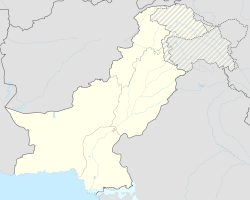
Wazirabad
|
Wazirabad وزیرآباد |
||
| State : |
|
|
| Province : | Punjab | |
| Coordinates : |
32 ° 45 ′ N , 74 ° 10 ′ E
|
|
| Residents : | 128,060 (2017 census) | |
| Time zone : |
PST ( UTC + 5 )
|
|
|
|
||
Wazirabad ( Urdu وزیرآباد) Is a city in the province of Punjab in Pakistan with 128,060 inhabitants (2017).
geography
Wazirabad is located on the banks of the Chanab River about 100 kilometers north of Lahore 62 meters above sea level .
The administrative area of the city includes the main towns Ahmad Nagar, Alipur, Kailianwala, Kialasike, Kotkhizari, Pathanky, Rasol Nagar, Saroki and Sohdra.
history
After the death of the Mughal ruler Aurangzeb Alamgir in 1707, the Sikhs gradually established themselves in the Punjab. The British East India Company took advantage of a moment of weakness in 1849 and ended Sikh rule over Wazirabad. After that, the area was part of the British Empire.
In 1947 with the independence of India and the division of the Punjab, the larger western part with Wazirabad became part of the new state of Pakistan. This division led to civil war-like conditions: Hindus fled to the east and Muslims to the west. Both sides carried out numerous massacres of the other group over several weeks.
Economy and Infrastructure
The local economy produces rice, sugar cane, grain, iron and steel, leather goods and surgical instruments, among other things.
Wazirabad is an important railway junction with connections to Faisalabad and Sialkot . The city is on the main route from Peshawar to Karachi . The railway line also runs over the Alexandra Bridge, opened in 1876 by the Prince of Wales , over the River Chanab.
