
Wedensee
| Wedensee | |
|---|---|

|
|
| Lake seen from the north bank towards Peckatel | |
| Geographical location | south of Penzlin , Mecklenburg Lake District , Mecklenburg-Western Pomerania , Germany |
| Tributaries | Stream from the Devil's Bridge |
| Drain | to the Klein Vieler See |
| Places on the shore | Penzlin north, Peckatel south |
| Location close to the shore | Peckatel |
| Data | |
| Coordinates | 53 ° 28 '6 " N , 13 ° 4' 21" E |
| Altitude above sea level | 52.5 m above sea level NHN |
| surface | 8 ha |
| scope | 2 km |
| Maximum depth | 1.5 m |
|
particularities |
silted up Grabensee |
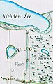
The Wedensee , a Grabensee , is embedded in a ground moraine landscape , with an area of about eight hectares in the municipality of Kleiniele in Mecklenburg-Western Pomerania.
description
The lake is designed as a blanket of a peat tub. The average water depth is around 1 meter, the water level is 52.5 m above sea level. The original water surface and depth is significantly reduced today. This is probably attributed to the amelioration of the surrounding agricultural areas. The elongated water surface was formerly about 900 meters long and 210 meters wide. The bank slopes rise 25 meters in the southeast and northwest. A silting up of the lake is not shown on a map from 1757. Since 2000 the Wedensee has been part of the European bird sanctuary "Lieps-Serrahn Forest and Lake Landscape". At the northeastern end of the lake there is a mostly dry ditch, which leads against the direction of flow of the surface water to a higher-lying small pond to the historic Teufelsbruch or Teufelsbrück . Two drainage ditches in the southwest to the Klein Vielener See were regulated with weirs in the past. In the 18th century the lake was also spelled Wehdensee.

View to the south bank
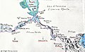
Wehden See 1766, drawing for a border dispute

Wedensee streams on the former Wehdenfurt, Bundesstrasse 193

Wedensee run under B 193 through to Klein Vielener See

Drainage ditch at the former Wehdenfurt in the Klein Vielener See


Slavonic land defense walls and ditches on the Wedensee
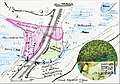
In the south of the town markings of Penzlin between the Klein-Vielener See and Prillwitz there is the Isern Purt (Iron Gate), a Slavic land barrier with water obstacles such as lakes, moors, ramparts and moats. This defense system was a border fortification, which, taking advantage of natural obstacles, such as the Wedensee, the small town lake, following the rosewood to Prillwitz, created a defensive border, a peoples divide in front of the entrance to the famous Retharians . An old map shows the medieval water level and course, you can see a field name between Wedensee and the Kleiner Stadtsee, the Teufelsbruch. At both ends of the elongated Wedensee there is a ground monument with about 2 to 3 meter high earth walls. The water level in the brooks could be regulated from time immemorial. Fragments of a weir for a plank wall made of hewn field stones can be seen in the northern connecting ditch between the Wedensee and the Klein Vielener See.
General view of the country barrier "Iron Gate"
Wedensee, three ramparts and double moats between Wedensee and Klein Vielener See

Double wall of the Landhemme between Wedensee and Teufelsbrück or Teufelsbruch

Four walls between the small town lake and the Eichsee / Zippelower Bachtal


Path and street tours on the Wedensee
In the Middle Ages, the Landhemme could only be passed at the end of the Penzlin Small City Lake, probably through the Iron Gate. A second path led from the Schwanen Heide from Peckatel in the direction of Penzlin over the Teufelsbruch, a narrow point at which the ramparts were interrupted. In the 12th century, the Radegast priests and residents of ancient Rethra fled through this bottleneck from the invading army of Henry the Lion. The Slav prince Wernike fled through the Iron Gate into his castle on the right bank of the Great Penzlin City Lake. With the construction of the road from Penzlin to Peckatel (B 193) in 1786, two creek ditches were merged into one creek ditch in the Penzliner Zipfel and laid under the street. The walls, which probably led to the Klein Vielener Lake, were probably leveled. The so-called Wehdenfurt was at this intersection of today's road across the stream . In the Wiebeking maps from 1786 the houses and gardens at the passage of the streams and ramparts of the former Landhemme are still drawn. The Peckateler village school family Wehden, which gave the lake its name, was based at this strategically toll-compatible passage point. (From the 15th century the Wehden / Weden / Wäden are mentioned in a document as Schulzen in Peckatel .)

Passage in the Middle Ages through the Iron Gate south of the Small City Lake

Escape routes of the Wendenfürsten Wernicke and the Radegastpriest from the army of Heinrich the Lion
Wehdenfurt , 1786 Construction of a country road (B 193) in the Penzliner Zipfel on the Wedensee

Newly laid out Penzlin-Peckatel road in 1786, map section Mecklenburg Strelitz 1790


literature
- FE Geinitz: The lakes, moors and rivers of Mecklenburg, origin of the lakes and rivers ... Opitz & Co., Güstrow 1886, p. 121.
Individual evidence
- ^ FE Geinitz: The lakes, moors and rivers of Mecklenburg . In: Formation of lakes and watercourses ... page 121 . Opitz & Co., Güstrow 1886.
- ^ Wilhelm Gottfried Beyer: The Landwehren and sanctuaries of the land of the Redarians. In: Year books of the Association for Mecklenburg History and Archeology / Volume 37. Document server of the Mecklenburg-Western Pomerania State Library, 1872, accessed on February 14, 2020 .
- ↑ A. Niederhöffer: Mecklenburgs Volkssagen : “The Saxons and their mighty Duke, Heinrich the Lion, armed with a large army, pull up for revenge! ... Wernicke also chased back through the iron gate with his family to the safe castle, while the residents of Rhetra and with them the Radegast priests tried to escape around the southern end of the Penzliner See through impassable, swampy areas. "
- Location according to the historical map:
- Measuring table sheet 2544: Hohenzieritz, 1911 Hohenzieritz. - Ed. 1884, report. 1911. - 1: 25000. - [Berlin]: Reichsamt für Landesaufnahme, 1911
- online excerpt: kartenforum.slub-dresden