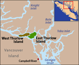
West Thurlow Island
| West Thurlow Island | |
|---|---|
| Waters | Salish Sea |
| Archipelago | Discovery Islands |
| Geographical location | 50 ° 24 ′ N , 125 ° 38 ′ W |
| length | 20.6 km |
| width | 5.4 km |
| Highest elevation | Solitary Mountain 560 m |
West Thurlow Island is an island between the mainland of the Canadian province of British Columbia and Vancouver Island . It belongs to the Strathcona Regional District and is part of the Discovery Islands .
| Hardwicke Island → Chancellor Channel |
Mainland → Cordero Channel |
|

|
Mayne Passage → East Thurlow Island | |
| Johnstone Strait → Vancouver Island | Nodal Channel → Sonora Island |
history
The island is located in the traditional hunting and settlement area of the Kwakwaka'wakw , a people of the First Nations .
The island was named by George Vancouver after the English Lord Chancellor Edward Thurlow, 1st Baron Thurlow . Only after their discovery was it noticed that they were two islands. The strait between the two islands was originally called the Blind Channel because it was overlooked by George Vancouver on his expedition. However, this strait was not so easy to explore for later expeditions because of its hidden location. The strait between the two islands was later renamed Mayne Passage .
Individual evidence
- ^ Origin Notes and History. West Thurlow Island. GeoBC , accessed September 25, 2015 .
