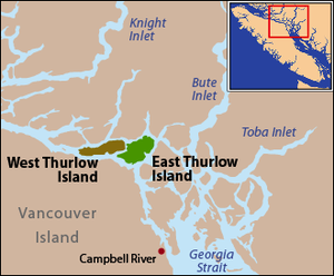
East Thurlow Island
| East Thurlow Island | |
|---|---|
| Waters | Salish Sea |
| Archipelago | Discovery Islands |
| Geographical location | 50 ° 25 ′ N , 125 ° 25 ′ W |
| Highest elevation | Mount Brougham 650 m |
East Thurlow Island is an island between the mainland of the Canadian province of British Columbia and Vancouver Island . It belongs to the Strathcona Regional District and is part of the Discovery Islands .
| Cordero Channel → Mainland | ||
| Mayne Passage → West Thurlow Island |

|
|
| Johnstone Strait → Vancouver Island | Nodal Channel → Sonora Island |
history
After the island was named after the English Lord Chancellor Edward Thurlow, 1st Baron Thurlow , it was discovered that it was two islands. The strait between the two islands was called the Blind Channel because it was overlooked by George Vancouver on his expedition. However, this strait was not so easy to explore for later expeditions because of its hidden location. The strait between the two islands was renamed Mayne Passage , but the old name was remembered by the residents of the new settlement at the eastern end of the sister island .
In 1910 the Thurlow Island Lumber Company built a sawmill with a total of 17 employees. Eight years later the population grew to 120 and regular ferry services were established. In addition, a canning factory, a clapboard mill and two large dance halls were built.
Around 1930, nine illegal distilleries were set up that produced drinks with a very high alcohol content. Two of them got their productions approved for those who prefer to trust the safety of the approved product.
Web links
- East Thurlow Island . In: BC Geographical Names (English)
Individual evidence
- ^ Origin Notes and History. East Thurlow Island. GeoBC , accessed September 25, 2015 .
