Western Hills Viaduct
Coordinates: 39 ° 7 ′ 29 ″ N , 84 ° 32 ′ 20 ″ W.
| Western Hills Viaduct | ||
|---|---|---|
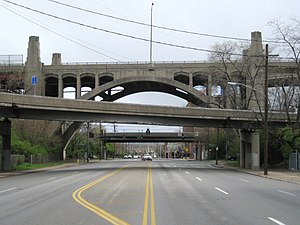
| Arch bridge on the east side over Spring Grove Avenue with entrances and exits from the mezzanine level to Interstate 75 | ||
| use | Road bridge | |
| Crossing of |
W → O: State Avenue, Mill Creek , Queensgate Yard , Spring Grove Avenue, Interstate 75 |
|
| place | Cincinnati ( Ohio ) | |
| Entertained by | City of Cincinnati Department of Transportation & Engineering (DOTE) |
|
| construction | Double-decker bridge of reinforced concrete | |
| overall length | 829 m | |
| Longest span | 37 m | |
| building-costs | 3.5 million US dollars | |
| opening | 1932 | |
| location | ||
|
|
||
|
The Western Hills Viaduct is on the border of the neighborhoods of Camp Washington (yellow) and Queensgate (red) |
||
The Western Hills Viaduct is an elevated road on the northern boundary of the Queensgate neighborhood of Cincinnati , Ohio . The nearly one kilometer long viaduct over the lower Mill Creek valley connects the neighborhoods of South Fairmont in the west and CUF in the east. It crosses the river, several streets and the Queensgate Yard of CSX Transportation . The double-decker bridge made of reinforced concrete leads four lanes on the upper and three on the lower level, whereby this on the east side only serves as a connection to the intersecting Interstate 75 to the south. The viaduct was built until 1932 as part of the new construction of the Cincinnati Union Terminal . The then largest passenger station in the city was closed at the beginning of the 1970s, the former tracks are now part of the neighboring freight and marshalling yards and the dispatch hall is a museum. Due to the poor condition of the elevated road, a new building is planned by the city and Hamilton County by 2028 . The volume of traffic in 2017 was around 55,000 vehicles per day.
history
The city center of Cincinnati is north of the Ohio in a lowland of Ice Age origin. The western boundary forms the lower valley of Mill Creek, which extends over the districts of Camp Washington and Queensgate to the Ohio. With the development of the higher-lying areas in the area at the beginning of the 19th century, the need for road connections arose, including to the west via the Mill Creek Valley. In the south, the first bridges were built above the mouth of the smaller river in the Ohio, but they were repeatedly victims of floods. By the end of the century, the course of the Mill Creek river was straightened and the first viaducts built over the valley, in which industrial areas and railway systems were built. The Liberty Street Viaduct was completed in 1891 and, two years later, in 1893, the 8th Street Viaduct south of it , which led west to Price Hill to one of several inclined elevators in the city. Further to the north, the Harrison Avenue Viaduct , which connected South Fairmont to the city, was built on the border of the districts of Camp Washington and Queensgate by 1908 . The 8th Street and Harrison Avenue viaducts were also used by streetcars , which were the primary mode of transportation in Cincinnati until the first half of the 20th century.
Cincinnati was served by up to 15 railroad companies around the turn of the century , which maintained a large number of inadequately interconnected passenger and freight stations in the city. In the 1920s, seven of the large companies therefore decided to build a joint passenger station in Queensgate, which was built in the lower part of the Mill Creek Valley by 1933. The Cincinnati Union Terminal , with a total of 150 km of track and a handling capacity of over 200 trains per day, stretched for almost 2 km along Mill Creek. The old steel viaducts in Queensgate had to give way to the large-scale project, for which new east-west connections made of reinforced concrete were built at the ends of the railway site. So by 1928 a new viaduct was built on 8th Street at the south end and by 1932 the new, over one kilometer long Western Hills Viaduct at the north end of the station, a few hundred meters north of the former and much shorter Harrison Avenue Viaduct (approx. 550 m).
With the onset of the expansion of the road network in the USA and the emergence of motorized private transport, the Cincinnati Union Terminal has increasingly lost its importance since the 1950s and was shut down in the early 1970s. The Queensgate Yard of CSX Transportation today takes up a large part of the former track system, the check-in hall has been preserved as the Cincinnati Museum Center at Union Terminal . The city's tram network also lost its importance and was shut down in the early 1950s. The volume of traffic over the Western Hills Viaduct was around 55,000 vehicles per day in 2017. Due to the poor condition of the elevated road , a new building is planned by the city and Hamilton County by 2028 .
description
The originally 829 m long reinforced concrete elevated road is divided into about 50 bridge fields, whereby the original total length - before the construction of Interstate 75 on the east side - was 1067 m. Arch bridges were integrated into the structure over Mill Creek and Spring Grove Avenue , with spans of 33 m and 37 m respectively. The fields in between have lengths of 13 to 17 m, the spans of the outer, newer fields are for the most part significantly longer. The double-decker bridge is up to 27 m high (upper level) and has a 12 m wide carriageway on both levels. The upper level also has a 1.8 m wide footpath on both sides. The viaduct originally had four lanes per level. On the east side, the upper level leads to the city center through a connection to US Highway 127 , the lower level was the connection to Spring Grove Avenue on the eastern edge of the valley, but became its entrance and exit with the construction of Interstate 75 in the early 1960s Departure and now only leads three lanes.
Web links
- Western Hills Viaduct: Reconstruction / Replacement Project. City of Cincinnati, Department of Transportation & Engineering, 2012.
- Western Hills Viaduct. City of Cincinnati, Department of Transportation & Engineering.
Individual evidence
- ^ JM Nickles: The Geology of Cincinnati. In: The Journal of the Cincinnati Society of Natural History. Vol. 20, 1901-1906, pp. 49-100, here pp. 49-52 ( digitized version ).
- ↑ City of Cincinnati: Cincinnati: A Guide to the Queen City and Its Neighbors. The Wiesen-Hart Press, 1943, p. 466.
- ^ Cincinnati Chamber of Commerce and Merchant's Exchange: Annual report. Vol. 41-42, Cincinnati 1891, p. 64.
- ^ Robert Bruce Fairbanks, Patricia Mooney-Melvin (eds.): Making Sense of the City: Local Government, Civic Culture, and Community Life in Urban America. Ohio State Univ. Press, 2001, ISBN 0-8142-0881-9 , p. 108.
- ↑ a b The Harrison Avenue Viaduct at Cincinnati. In: Engineering record, building record and sanitary engineer. Vol. 58, No. 16, October 17, 1908, pp. 429-431.
- ^ Historical Atlas of Cincinnati. Northern Kentucky University, accessed March 28, 2019.
- ↑ Railroad Improvement and Safty plan. City of Cincinnati, Department of Transportation and Engineering, 2013, pp. 6-10.
- ↑ a b About Union Terminal. Cincinnati Museum Center, accessed March 23, 2019.
- ^ A b Walter S. Lacher: Cincinnati's New Union Terminal Now in Service. In: Railway Age. Vol. 95, No. 16, 1933, pp. 575-590, here p. 590.
- ↑ Carol Motsinger: How the streetcar shaped Cincinnati. Cincinnati Enquirer, September 6, 2016. Retrieved March 29, 2019.
- ^ A b Western Hills Viaduct: Reconstruction / Replacement Project. City of Cincinnati, Department of Transportation & Engineering, 2012, accessed March 28, 2019.
- ^ Western Hills Viaduct. City of Cincinnati, Department of Transportation & Engineering, accessed March 28, 2019.
- ^ Western Hills Viaduct. National Bridge Inventory, Structure number: 3137082, BridgeReports.com. Retrieved March 29, 2019.


