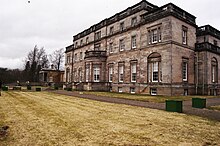
Whittingehame House
Whittingehame House is a mansion near the Scottish hamlet of Whittingehame in the East Lothian Council Area . In 1971 the building was included in the Scottish List of Monuments in the highest category A. Furthermore, the associated East Lodge and West Lodge are each independently classified as Category A structures. A monument ensemble does not exist. Most recently, the associated gardens were included in the Scottish Register of Landscape Gardens.
history
Prior to 1372, the Whittingehame lands were owned by the Earls of March . By marriage they fell to the Douglas clan in that year and remained in their possession for centuries. In the late 15th or early 16th century, the Tower House Whittingehame Tower was built there , which is located around 300 m west of Whittingehame House. Allegedly, in the 1560s, James Douglas, 4th Earl of Morton and James Hepburn, 4th Earl of Bothwell, met on the estate for the assassination of Henry Stuart, Lord Darnley , consort of Queen Mary of Scots and formally King of Scotland, prepare. In 1660 the lands came into the possession of the Seton clan and later the Hay clan through marriage . In 1817 they sold Wittingehame to James Balfour .
In the same year Balfour initiated far-reaching measures, including the construction of Whittingehame House. Furthermore, Balfour began to lay out the surrounding park landscape and moved the village of Wittingehame to the south bank of the Luggate Burn and thus closer to the manor house. The mansion was completed in 1825. After James Balfour's death, the property passed to his son James Maitland Balfour , who in turn bequeathed it to the future Prime Minister Arthur James Balfour . This contributed to the development of the property. Until 1963 Whittingehame House was inherited within the family. Since then it has changed hands several times.
From January 1939 to September 1941, Whittingehame House housed the Whittingehame Farm School , a training facility for children and young people who had come to Great Britain on the Kindertransport .
description
The manor is located on the south bank of the Whittingehame Waters not far from the hamlet of Wittinghame. It was designed in the classical Greek Revival style based on a design by the English architect Robert Smirke . William Burn redesigned the building in 1827. The masonry of the two-story mansion is made of sandstone . The northeast-facing front is symmetrical and nine axes wide. The central entrance area is striking. It is designed with a portico with Doric columns. An opening on the rear, which is also nine axes wide, leads to a small terrace, from which a staircase leads down into the gardens. A balustrade runs around the roof level and largely hides the slate roofs.
East Lodge
The East Lodge flanks an access road to Whittingehame House. It is located about 1.5 km northeast of the manor on the north bank of the Whittingehame Burn. Unlike the West Lodge designed by Smirke, the East Lodge may be the work of William Burns. The one-story building, built around 1827, is designed in the Greek Revival style with Doric columns, like the manor house. In an extension around 1986, attention was paid to maintaining the style. Only an attached winter garden does not fit into the picture.
West Lodge
The West Lodge is located on the north bank of Whittingehame Water around 1.8 km southwest of Whittingehame House. It was built around 1820 in the Greek Revival style according to a design by Smirkes and flanks the western access road to the manor house. The one-story building has an L-shaped floor plan. The three-axis front is reminiscent of a temple. It is designed with Doric columns. The door closes with a fighter window . The roof is covered with gray slate. The driveway is flanked by pillars with a square plan. The two-winged, wrought iron gate is relatively simple.
Individual evidence
- ↑ a b c Listed Building - Entry . In: Historic Scotland .
- ↑ a b Listed Building - Entry . In: Historic Scotland .
- ↑ a b Listed Building - Entry . In: Historic Scotland .
- ↑ a b c Garden and Designed Landscape - entry . In: Historic Scotland .
Web links
- Entry on Whittingehame House in Canmore, Historic Environment Scotland database
Coordinates: 55 ° 57 '7.6 " N , 2 ° 37" 58.7 " W.


