Willoughby's Land
Willoughby's Land is a phantom island in the Barents Sea that was found on maps of the Arctic Ocean from the late 16th to the mid 17th centuries.
Sir Hugh Willoughby made the first attempt to reach China via the Northeast Passage in 1553 on behalf of English merchants . At 72 degrees north of latitude, he came across the Novaya Zemlya coast , but his geographical longitude was much too far to the west. Later seafarers such as Arthur Pet (1580), Willem Barents (1594) and Henry Hudson (1608) did not find a land at the specified position.
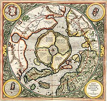
Willoughby's Land appears on Petrus Plancius' map of the north polar region from 1594 as well as on Gerhard Mercator's 1595 posthumously published map west of Novaya Zemlya. Even Plancius did not believe in their existence. Because Barents could not find the island, it is not listed on his 1599 map. On other maps, for example by Johannes Janssonius and Willem Blaeu , it can still be found at least until the 1640s.
literature
- William James Mills: Exploring Polar Frontiers - A Historical Encyclopedia , ABC-CLIO, 2003. ISBN 1-57607-422-6
- Derek Hayes: Historical Atlas of the Arctic . Douglas & McIntyre, Vancouver 2003. ISBN 0-295-98358-2
Individual evidence
- ↑ Louwrens Hacquebord: In Search of “Het Behouden Huys”: A Survey of the Remains of the House of Willem Barentsz on Novaya Zemlya (PDF; 799 kB). In: Arctic Volume 48, No. 3, 1995, pp. 248-256.

