Willows Nunatak
| Willows Nunatak | ||
|---|---|---|
|
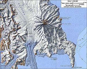
Map of Mount Melbourne with the Willows Nunatak (bottom right) |
||
| height | 380 m | |
| location | Victoria Land , East Antarctica | |
| Mountains | Transantarctic Mountains | |
| Coordinates | 74 ° 29 ′ 0 ″ S , 165 ° 17 ′ 0 ″ E | |
|
|
||
The Willows nunatak is a 380 m high nunatak on the Borchgrevink coast of the East Antarctic Victoria Land . It rises 1.5 km inland on the south bank of Wood Bay from the saddle between Cape Washington and Mount Melbourne .
The United States Geological Survey mapped it based on its own surveys and aerial photographs of the United States Navy from 1955 to 1963. The Advisory Committee on Antarctic Names named it in 1968 after A. O. Dennis Willows, who was a biologist at McMurdo Station from 1965 to 1966 was active.
Web links
- Willows Nunatak in the Geographic Names Information System of the United States Geological Survey (English)
- Willows Nunatak on geographic.org (English)

