Mount Melbourne
| Mount Melbourne | ||
|---|---|---|
| height | 2732 m | |
| location | Victoria Land , East Antarctica | |
| Coordinates | 74 ° 21 ′ 0 ″ S , 164 ° 42 ′ 0 ″ E | |
|
|
||
| Type | Stratovolcano | |
| Last eruption | around 1892 | |
|
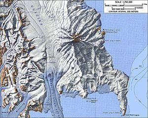
Mount Melbourne topographic map (1: 250,000 scale) |
||
The Mount Melbourne is a large, 2,732 m high stratovolcano at the Borchgrevink Coast of the East Antarctic Victoria Land . It rises inland from Cape Washington and, as a striking landmark, dominates the stretch of coast between Wood Bay and Terra Nova Bay .
The area around today's Mount Melbourne from Cape Washington in the south to the Random Hills in the north has been showing volcanic activity since the beginning of the Pleistocene about 2.6 million years ago . The mountain cone of Mount Melbourne with a volume of around 180 km³ was one of the younger volcanoes in the area only formed during the last 123,000 years. Deposits of volcanic ash in the ice suggest that the last eruption of Mount Melbourne probably occurred between 1862 and 1922. At present, volcanic activity is limited to fumaroles and geothermal phenomena.
Ice-free areas on the summit crater and on the northwest flank of the mountain mark the zones of geothermal activity, in which the soil temperature can be up to 50 ° C at a depth of a few centimeters. In these places a biological community has developed that includes three types of mosses , five types of green algae , six types of fungi , a representative of the euglyphida, as well as six types of cyanobacteria and eleven types of other bacteria . Due to the uniqueness of this community and its importance for research, these areas have been designated as a particularly protected area of the Antarctic .
The British polar explorer James Clark Ross discovered the mountain in January 1841 during his Antarctic expedition (1839-1843). He first named it Mount Etna because of its resemblance to Mount Etna in Sicily. He later named it after William Lamb, 2nd Viscount Melbourne (1779-1848), who had supported Ross' expedition plans during the time as British Prime Minister between 1835 and 1841.
Web links
- Melbourne in the Global Volcanism Program of the Smithsonian Institution (English).
- Skiing the Pacific Ring of Fire and Beyond: Mount Melbourne. In: skimountaineer.com. Amar Andalkar (English).
Individual evidence
- ↑ Guido Giordano et al .: Stratigraphy, geochronology and evolution of the Mt. Melbourne volcanic field (North Victoria Land, Antarctica) . In: Bulletin of Volcanology . tape 74 , no. 9 , November 2012, p. 1985–2005 , doi : 10.1007 / s00445-012-0643-8 (English, freely available online through researchgate.net ).
- ^ Graeme L. Lyon: Stable isotope stratigraphy of ice cores and the age of the last eruption at Mount Melbourne, Antarctica . In: New Zealand Journal of Geology and Geophysics . tape 29 , no. 1 , 1986, ISSN 0028-8306 , pp. 135-138 , doi : 10.1080 / 00288306.1986.10427528 (English).
- ↑ Management Plan For Antarctic Specially Protected Area No. 175: High Altitude Geothermal Sites of the Ross Sea region (including parts of the summits of Mount Erebus, Ross Island and Mount Melbourne and Mount Rittmann, northern Victoria Land). Excerpt from: Secretariat of the Antarctic Treaty (Ed.): Final Report of the Thirty-seventh Antarctic Treaty Consultative Meeting . tape 2 . Buenos Aires 2014, ISBN 978-987-1515-83-7 , pp. 199-225 (English).
- ^ John Stewart: Antarctica - An Encyclopedia . Vol. 2, McFarland & Co., Jefferson and London 2011, ISBN 978-0-7864-3590-6 , p. 1024 (English).


