Wisch (Creuzburg)
| Wipe | ||
|---|---|---|
|
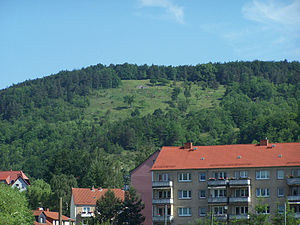
View to the Wisch with the Kossenhaschen crypt |
||
| height | 363 m above sea level NN | |
| location | Thuringia , Germany | |
| Coordinates | 51 ° 3 '37 " N , 10 ° 14' 21" E | |
|
|
||
| rock | Shell limestone | |
| particularities | Lookout point, family crypt | |
The Wisch is now a partially wooded mountain and is considered the local mountain of Creuzburg in the Wartburg district . It is part of the Eichsfeld-Hainich-Werratal Nature Park . At the north-eastern tip of the mountain there is an open pasture area with a panoramic view of the north-western Thuringian Forest with the Wartburg and the Werra Valley Bridge near Hörschel. The mountain plateau has a peak height of 363 m above sea level. HN and was extensively cleared in the Middle Ages, field terraces, reading stone walls and vaulted bakers are still clearly visible in the area. Currently, splintered areas are still used as pasture and some gardens and orchards on the southern slope. Wine is said to have been grown on steep slopes. In an easterly direction, the nature reserve of the Nordmansteine and Ebenau heads connects.
An entrance leading into the mountain can be seen on the southern slope of the Wisch. The ruins of the so-called Kossenhaschen Crypt are the unfinished and therefore never used hereditary burial of the Erfurt hotelier and art patron Georg Kossenhaschen (1868–1931), who had acquired Creuzburg Castle in 1921 . Kossenhaschen found his final resting place in the Erfurt Südfriedhof.
Several hiking trails lead across the Wisch to the neighboring town of Treffurt and into the Unstrut-Hainich district .
Individual evidence
- ↑ Official topographic maps of Thuringia 1: 10,000. Eichsfeldkreis, LK Nordhausen, Kyffhäuserkreis, Unstrut-Hainich-Kreis . In: Thuringian Land Survey Office (Hrsg.): CD-ROM series Top10 . CD 1. Erfurt 1999.

