Woronora River
| Woronora River | ||
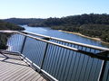
 Woronora River from the Woronora Bridge |
||
| Data | ||
| location | New South Wales , Australia | |
| River system | Georges River | |
| Drain over | Georges River → Tasman Sea | |
| source | at Darkes Forest 34 ° 12 ′ 5 ″ S , 150 ° 54 ′ 4 ″ O |
|
| Source height | 353 m | |
| muzzle |
Georges River at Como and Illawong coordinates: 33 ° 59 '47 " S , 151 ° 3' 40" O 33 ° 59 '47 " S , 151 ° 3' 40" O |
|
| Mouth height | 0 m | |
| Height difference | 353 m | |
| Bottom slope | 9.8 ‰ | |
| length | 36.1 km | |
| Reservoirs flowed through | Lake Woronora | |
| Big cities | Sydney | |
The Woronora River is a river in the east of the Australian state of New South Wales .
geography
The river rises north of Darkes Forest. From there it flows north and flows into the Georges River at Como and Illawong .
Reservoir
Lake Woronora , which is part of Sydney's drinking water supply, is located on the upper reaches .
River crossings
In Woronora , a high bridge, a low road bridge and a pedestrian bridge cross the river. In Heathcote , the road bridge on Heathcote Road connects this district with Holsworthy.
In Engadine , near Woronora Road, there is the bridge The Needles , which provides the transition to the Barden Bridge . However, it is closed to cars.
Gallery images

Woronora Bridge, view of Sutherland
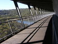
Pedestrian walkway on Woronora Bridge.