
Yulong river
| Yulong | ||
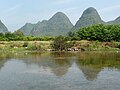
 Karst mountains on the Yulong River |
||
| Data | ||
| location | Autonomous Region Guangxi Zhuang ( China ) | |
| River system | Pearl river | |
| Drain over | Li Jiang → West River → (partly Pearl River) → South China Sea | |
| muzzle | in the Li River coordinates: 24 ° 46 ′ 21 " N , 110 ° 30 ′ 25" E 24 ° 46 ′ 21 " N , 110 ° 30 ′ 25" E
|
|
| length | 35 km | |
| Big cities | Guilin | |
The Yulong River ( Chinese 遇龙河 , Pinyin Yulong Hé ) is a 43.5 km long, 38 to 61 meters wide and up to 2 feet deep to flow in the autonomous region of Guangxi of Zhuang in the People's Republic of China .
course
The Yulong River flows through the Guilin and Yangshuo counties before flowing into the Li River , a tributary of the West River. Like the Li River, it is particularly famous for its landscape. It flows about 15 kilometers west of the city of Yangshuo through a karst landscape, which in China is the epitome of a beautiful landscape.
Picture gallery

Bird's eye view

from the Dragon Bridge

Yulong Bridge

Rafts

Rafters
Mountains on the shore


Web links
Commons : Yulong River - collection of pictures, videos and audio files