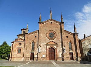
Zibello
| Zibello | |||
|---|---|---|---|

|
|||
| Church of Santi Gervasio e Protasio (16th century) | |||
| Country | Italy | ||
| region | Emilia-Romagna | ||
| province | Parma (PR) | ||
| local community | Polesine Zibello | ||
| Coordinates | 45 ° 1 ′ N , 10 ° 8 ′ E | ||
| height | 35 m slm | ||
| surface | 23.62 km² | ||
| Residents | 1,818 (Dec. 31, 2015) | ||
| Population density | 77 inhabitants / km² | ||
| patron | San Carlo | ||
| Telephone code | 0524 | CAP | 43016 |
Zibello is a fraction of the Italian comune ( comune ) Polesine Zibello in the province of Parma , Emilia-Romagna region .
geography
Zibello is located about 28 kilometers northwest of Parma on the right bank of the Po in close proximity to the province of Cremona at 35 m slm The residents are known as Zibellini .
history
Zibello was already settled in pre-Roman times. There is evidence of a chapel since the 9th century. Until 2015, Zibello was an independent municipality. On January 1, 2016, he merged with Polesine Parmense to form the new municipality of Polesine Zibello . The community had the end of 2015 1818 inhabitants and an area of 23.5 square kilometers and consisted of the fractions Ardola, Pieveottoville and Rota Ancone. The Po formed the northern boundary of the municipality.
particularities
The ham Culatello di Zibello is considered to be of particularly high quality.
Web links
Individual evidence
- ^ Polesine Parmense e Zibello (Pr): la fusion è legge. Nasce il comune unico di Polesine Zibello. In: assemblea.emr.it. Retrieved November 26, 2019 (Italian).