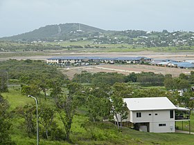
Cilzie
| Cilzie | |||||
|---|---|---|---|---|---|

|
|||||
|
|||||
|
|||||
|
|||||
|
|||||
|
|
|||||
Zilzie is a place on the east coast of Queensland in Australia and had a population of 2,713 in 2016. The name goes back as an anagram to the wife of a previous landowner named Lizzie.
geography
Zilzie is located directly on the Coral Sea around 30 kilometers east of Rockhampton and 650 kilometers north of Brisbane . Zilzie has been part of the Shire of Livingstone since 2013 .
To the west of Zilzie is Coorooman inland and to the north is Emu Park . To the east of the town of Zilzie is the beach and immediately to the west is the Capricorn Coast National Park , which extends to the Coral Sea in the south. The Cawarral Creek and the Coorooman Creek pour into the sea at the southern end of the village.
Population development
- 2006: 1153
- 2011: 1890
- 2016: 2713
education
Zilzie has no schools, but the neighboring towns of Emu Park, Coorooman and Coowonga each have a public school.
Individual evidence
- ↑ a b c Australian Bureau of Statistics : Zilzie ( English ) In: 2016 Census QuickStats . June 27, 2017. Retrieved April 15, 2020.
- ↑ http://www.onthehouse.com.au/suburb/qld/zilzie_4710
- ^ Australian Bureau of Statistics : Zilzie ( English ) In: 2011 Census QuickStats . March 28, 2013. Retrieved May 4, 2016.
- ↑ http://www.goodschools.com.au/schools-in/zilzie-4710/
