Ramla cistern
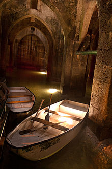
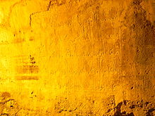
The Ramla Cistern (also Helena Basin, Hebrew בריכת הקשתות brichat hakeschatot , arab. Bīr al-Anezīya ) is an underground water reservoir in the north of the Israeli city of Ramla . It was built in the reign of the Abbasid caliph Hārūn ar-Raschīd in 789 and served to supply the city of Ramla with water. The year of construction is given by an Arabic inscription at the entrance to the cistern:
“ In the name of the merciful and gracious God ... This was set up by order of Dinar, the administrator of the emir of believers, may Allah extend his rule. The factory was built by Abd ... in 172. "
The cistern has been preserved over the centuries as a unique example of Islamic architecture , despite numerous earthquakes in the region ; the water was drawn from an aqueduct in the Gezer region . In 2008 it was closed for structural safety reasons to avoid a collapse, and the State Office for the Conservation of Antiquities had stabilization measures carried out.
Dimensions and names
The water basin is rectangular, with side dimensions of 19.82 by 21.7 meters. The area is 430 m², the height around nine meters, the volume around 5700 m³.
The name Helena-Becken comes from the Christian tradition and is traced back to Helena , the mother of Constantine the Great .
The Arabic name Bīr al-Anezīya ("goat basin") indicates that goats were watered here in earlier times.
meaning
The cistern is the only building in Israel that can be assigned with certainty to the Abbasid period. The roof rests on three rows of columns, each row counting five columns connected by pointed arches . This is the first example of using the ogival shape. Crusaders may have brought this construction with them on their way back to Europe. The pointed arch became a basic construction method of Gothic architecture in the 12th century .
Web links
Individual evidence
- ↑ according to the hijra
- ^ A b The Pool of the Goats .
- ^ Israel Authority Antiquities, Conservation Department
- ^ The Pool of Arches
- ^ Richard C. Schneider : ARD Tel Aviv ( Memento from May 20, 2015 in the Internet Archive )
Coordinates: 31 ° 55 ′ 55 ″ N , 34 ° 52 ′ 16 ″ E

