
Zorakars
| Zorakars Karahundsch | |||
|---|---|---|---|
 Megaliths of Zorakars |
|||
|
|||
| Coordinates | 39 ° 33 '6 " N , 46 ° 1' 40" E | ||
| place | near the city of Sissian , Syunik , Armenia | ||
| Emergence | Middle Bronze Age to Iron Age | ||
| Dimensions | 7 ha | ||
| height | 1770 m | ||

Zorakarer ( Armenian : Զորաց Քարեր "Stone Army") is a Bronze Age burial ground with an ancient settlement in Armenia . It is located near the city of Sissian in the province of Sjunik . An alternative name is Karahundsch (Armenian: Քարահունջ "Stone Collection" (vmtl.), In English translation Karahunj ).
Description of the plant
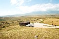
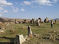
The approximately 7 hectare field is located on a promontory in the Armenian highlands on the southern edge of the Caucasus . There are about 30 chamber graves, some of them very large, as well as the remains of a settlement wall. Towards the high plateau to the east, the burial ground and settlement are bounded by a row of around 150 upright boulders ( megaliths ). In total there are 223 such boulders in various formations on the site. About 40 of them form a circle around the central stone chamber grave of the town. They are made of basalt, have a height of 2–3 m and an estimated weight of up to 10 t.
The Zorakarer burial ground was robbed long ago. That is why the cap stones are missing from most of the graves today. The central stone chamber tomb was also looted, but kept almost all of its capstones. The 5 untouched graves from the early Iron Age were excavated in the 1980s by the archaeologist Onnik Xnkikyan. He found grave goods in them, including clay vessels and necklaces, as well as earrings, daggers and bronze arrowheads. In the History Museum of the nearby city of Sissian, some of these grave goods are exhibited together with finds from other Bronze and Iron Age graves of Sissian.
Chronology and interpretation of the system
.jpg)
In 2000 and 2001, the archaeologist Stephan Kroll carried out two inspections on the Zorakarer site in cooperation with the Institute for Archeology and Ethnography of the Armenian Academy of Sciences. All superficially visible chamber graves were measured, photographed and their location was determined with GPS .
Like Xnkikyan, Kroll came to the conclusion that the burial ground was laid out in the Middle Bronze Age (20th – 16th centuries BC). With interruptions, the place was then used as a burial place until the early Iron Age (12th – 9th centuries BC). The size and content of the graves suggest that primarily people of higher rank were buried here. The very large, centrally located stone chamber grave is said to have been created during this time. Xnkikyan dates it to the beginning of the 1st century. v. Chr.
Much later, in the Hellenistic-Roman period (3rd century BC - 3rd century AD), there was a settlement on the site. Kroll suspects that it served the residents of the area as a retreat in times of war. To protect the settlement, a wall made of boulders and clay was built. Only the boulders that were erected to strengthen the wall remain of this wall today. A similar city wall is said to have existed in Uyts , an ancient city, the remains of which are a few kilometers from Zorakarer.
There are contradicting views about the age and function of these boulders. Some scientists date the boulders to a much earlier time and see them as the oldest part of the entire place. It is also unclear why boulders were also placed around the central stone chamber grave. This has led to speculation about the use of the grave as a prehistoric place of worship (see the section "Alternative interpretations").
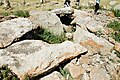
Megaliths with holes

.jpg)
The fact that there are circular holes in some megaliths, as well as in three cap stones of the central stone chamber tomb, has led to speculation and controversy. A total of 84 stones have holes in them, some of which are now damaged or destroyed. At their narrowest point, the holes have a diameter of about 5 cm and a depth of up to 20 cm. It is not clear what they were used for. It is also unknown whether they were inserted when the stones were erected or at a later time. What is certain, however, is that there are megaliths with holes in other archaeological locations in Armenia.
One hypothesis is that the holes were used to transport and erect the basalt stones. This is supported by the fact that they are rounded on the outside. With some stones it can be clearly seen that the rounding or wear of the holes is greatest in the direction in which the stones would sensibly be pulled with ropes. Therefore, the hypothesis that the holes were used for transport is still the most plausible - even if some holes would break out in the current state of the stones with such a method of transport. It remains unclear why only some of the stones have holes. It is also not understandable why three holes were inserted into the stones at right angles and why three stones each have two holes.
Alternative interpretations
Zorakarer has long captured people's imaginations. A local legend tells of giants who are said to have lived in this place once. Another from a military leader who is believed to be buried in the town's central stone chamber tomb while his warriors would rest under the upright boulders. Researchers, on the other hand, suspected an old cult site at this location for some time. In the 1980s, because of the holes in the boulders, the theory arose that Zorakarer was a prehistoric sun, moon and star observatory . According to some researchers, up to four stone holes are said to point to the point on the horizon where the sun rises on midsummer's day . Up to four more holes should be aimed at the point of sunset that day. However, the holes in the stones are quite coarse and due to their rounded shape you can aim at different directions in the sky (which you can see for yourself as a visitor). However, over time, this theory became more popular. Today, many Armenians see Zorakarer as the "Armenian Stonehenge " (assuming the popular scientific assumption that Stonehenge is a prehistoric observatory).
In 1983 and 1987 the astrophysicist Elma Parsamian examined the place and was convinced of the original function of the megaliths as an astronomical observation facility . Following up on her work, the radio physicist and radio astronomer Paris Herouni (died 2008) carried out further investigations from 1994 onwards. He recognized the central stone chamber tomb, which is surrounded by around 40 boulders, as a temple for the Armenian sun god Aramazd . He also saw a large and highly developed celestial observatory with a university in the row of about 150 boulders. He dated the age of the building to over 7,500 years. In September 2010, the astrophysicist Mihran Vardanyan tried to substantiate the observatory theory through the "Stars & Stones 2010" expedition in conjunction with the Royal Geographical Society of Oxford University . The theory of the prehistoric observatory propagated by him and others with effective media coverage is rejected by archeology as "pseudo-archaeological speculation".
Names of the place
Since time immemorial, the place has had the Turkish name "Koşun taş", German: "Stone Army". It probably got this name because the megaliths look like soldiers from a distance. It was only in the 1980s that it was renamed “Zorakarer” or “Zorats Kar (er)”. This designation is the Armenian translation of the Turkish name. The local population also calls the place "Dig-dig Karer", which means "upright stones".
But Parsamian brought Zorakarer in connection with the name "Karahundsch". She saw a resemblance to the megaliths of Stonehenge in the boulders around the stone chamber tomb and noticed that there is a village in the region whose name "Karahundsch" seems to be similar to the name "Stonehenge". Herouni later stated that the 13th century bishop and historiographer Stephanos Orbeljan mentions a village called “Karundsch” in his book “The History of Sjunik”, which is said to have been near the town of Sissian. This observation and further considerations led him to believe that this is the original name of Zorakarer. From the mid-1990s he campaigned for the place to be renamed the “Karahundsch Observatory”. Armenian politics followed the theories of astrophysicists. In 2004 the place was officially named "Karahundsch Observatory" through a parliamentary resolution.
Parsamian, Herouni and other Armenian astrophysicists point to the similarity of the names "Karahundsch" and "Stonehenge". Because “kar” means “stone” in English. And “hundsch” sounds similar to how the word “henge” is pronounced in English. The meaning of "hundsch" is not certain. Armenian philologists assume that the word comes from “pundsch”, German: “Strauss” or “Collection”. The astrophysicists, on the other hand, have other explanations for the meaning of "hundsch". In any case, they assume that the names "Karahundsch" and "Stonehenge" are related, because they believe that Zorakarer was the model for Stonehenge - and other henges . Linguists, on the other hand, see no common origin for these names.

Archaeoastronomy and Tourism
The interest of the Armenian astrophysicists in Zorakars must be seen in the context of the special status that astronomy has had in Armenia for several decades. The interpretation of Zorakarer as the oldest celestial observatory in the world is also an expression of the wish of some Armenian circles to make Armenia internationally known as the cradle of astronomy. For this purpose, archaeological sites are interpreted archaeoastronomically and occasionally historical, archaeological and linguistic findings are ignored or interpreted in their own way.
The megaliths of Zorakarer are not the only prehistoric structure in Armenia to which astrophysicists ascribe an astronomical function. A rock formation next to the Bronze Age fortress Metsamor , which Parsamian examined as early as the 1960s, has since also been regarded as a prehistoric observatory. Further archaeological finds such as the petroglyphs of Ughtasar are also supposed to show the astronomical and cosmological knowledge of the early Armenians.
Ultimately, the efforts of astrophysicists to give archaeological sites an archaeoastronomical meaning are also aimed at the development of tourism. It is hoped that this will generate economic impetus, especially for structurally weak regions such as Sjunik. Zorakarer plays a central role and has meanwhile become one of the most famous archaeological sites in Armenia. Every year thousands of tourists are brought in buses to this place, which is located on the important M2 trunk road . 7 multilingual information boards (Arm.-Engl.-Russian-Ital.-French), which were set up throughout the site, as well as a small souvenir shop mainly inform visitors about the hypotheses of the astrophysicists about this place. So far, the area is completely unprotected, so that visitors can move around it freely and unobserved. Astrophysicists lament this state of affairs and point out that there has been a noticeable decline in the site over the past 100 years.
Picture gallery
- Zorakars
View of the plant from the southeast

Settlement remains

Stone circle and central stone chamber tomb
View of the central stone chamber tomb
Row of stones

Part of the stone circle around the central grave

Row of stones

Part of the stone circle around the central stone chamber tomb


Web links
Individual evidence
- ↑ a b http://www.armenianmonuments.org/en/monument/Karahundj/104
- ↑ http://www.armenianmonuments.org/en/monument/Karahundj/108
- ↑ Xnkikyan, Onnik S. (2002): Syunik During the Bronze and Iron Age, translated by Vatche Ghazarian, Barrington: Mayreni Publishing, pp. 60-62, 201 f.
- ↑ http://www.sisianmuseum.am/gallery.php?lng=1&parent_id=3
- ↑ http://www.biainili-urartu.de/Armenia/2001/Kapan-2001-Detail.html
- ↑ http://www.biainili-urartu.de/Armenia/2000/Sisian-Survey.html
- ↑ Xnkikyan, Onnik S. (2002): Syunik During the Bronze and Iron Age, translated by Vatche Ghazarian, Barrington: Mayreni Publishing, p. 26
- ↑ http://www.biainili-urartu.de/Armenia/2000/Armenia-2000.html
- ↑ http://www.armenianmonuments.org/en/monument/Karahundj/109
- ↑ a b c d http://www.wondermondo.com/Countries/As/Armenia/Syunik/Karahunj.htm
- ↑ Lisitsian, St. (1935): Koshun-dash. Megaliticheskoye Gorodishche v Sisiane (Zangezur). In: Akademiya Nauk SSSR XLV Akademiku N. Ya. Marru, Moscow-Leningrad: Academy of Sciences of the USSR, p. 714. http://library.udpu.org.ua/library_files/rarutetu/rarutetu/21703.pdf
- ↑ a b c PRESERVATION AND MAINTENANCE OF THE ASTRONOMICAL SITES IN ARMENIA ( Memento from June 6, 2012 on WebCite )
- ↑ http://www.armenianmonuments.org/en/monument/Karahundj/105
- ↑ Herouni, Paris M. (2004): Armenians and Old Armenia; archaeoastronomy, linguistics, oldest history; Yerevan: Tigran Mets
- ↑ http://qarahunge.icosmos.co.uk/goals.php
- ↑ en: Pseudoarchaeology
- ↑ a b http://www.armenianmonuments.org/en/monument/Karahundj/110
- ↑ Parsamyan, ES (1985): O Vozmozhnom astronomicheskom naznachenii megaliticheskikh kolets Angelakota. In: Byurakani astġaditarani haġordumner, Volume 57, Yerevan: Academy of Sciences of the ASSR, p. 103. http://byurakan.asj-oa.am/351/1/1985-57%28101%29.pdf
- ↑ Herouni, Paris M. (2004): Armenians and Old Armenia; archaeoastronomy, linguistics, oldest history; Yerevan: Tigran Mets, p. 9
- ↑ https://www.e-gov.am/gov-decrees/item/889/
- ^ Bochkarev, Nikolai G., Bochkarev, Yuri N. (2005): Armenian archaeoastronomical monuments Carahunge (Zorakarer) and Metsamor. In: Cosmic Catastrophes., Tartu: Tartu University, pp. 43-53
- ↑ http://www.armenianheritage.org/u_files/file/AMAP-all-en.pdf
- ^ Bochkarev, Nikolai G., Bochkarev, Yuri N. (2005): Armenian archaeoastronomical monuments Carahunge (Zorakarer) and Metsamor. In: Cosmic Catastrophes., Tartu: Tartu University, p. 41 f.