
Ha Ha Tonka State Park: Difference between revisions
No edit summary |
Fixed a typo Tags: Mobile edit Mobile web edit |
||
| (18 intermediate revisions by 15 users not shown) | |||
| Line 1: | Line 1: | ||
{{short description|State park in Missouri, United States}} |
|||
{{For|the band|Ha Ha Tonka}} |
|||
{{Use mdy dates|date=August 2023}} |
|||
{{Infobox protected area |
{{Infobox protected area |
||
| name = Ha Ha Tonka State Park |
| name = Ha Ha Tonka State Park |
||
| Line 14: | Line 15: | ||
| relief = 1 |
| relief = 1 |
||
<!-- location --> |
<!-- location --> |
||
| location = [[Camden County, Missouri|Camden]], Missouri, United States<ref name=parks2/> |
| location = [[Camden County, Missouri|Camden County]], Missouri, United States<ref name=parks2/> |
||
| nearest_city = |
| nearest_city = |
||
| nearest_town = |
| nearest_town = |
||
| Line 52: | Line 53: | ||
}} |
}} |
||
'''Ha Ha Tonka State Park''' is a public recreation area encompassing over {{convert| |
'''Ha Ha Tonka State Park''' is a public recreation area encompassing over {{convert|5000|acre}} on the [[Niangua River|Niangua]] arm of the [[Lake of the Ozarks]], about five miles south of [[Camdenton, Missouri|Camdenton]], [[Missouri]], in the [[United States]]. The [[state park]]'s most notable feature is the ruins of Ha Ha Tonka, an early 20th-century stone mansion that was modeled after [[European castle]]s of the 16th century. |
||
The park also features [[cave]]s, [[sinkhole]]s, and bluffs overlooking the [[reservoir|lake]]. It is a prominent example of [[karst]] topography, which is geological formation shaped by the dissolution of a layer or layers of soluble bedrock.<ref name=parks/> A {{convert|70|acre|adj=on}} portion of the park was designated as the Ha Ha Tonka Karst Natural Area in 1981.<ref name=naturalareas/> |
The park also features [[cave]]s, [[sinkhole]]s, and bluffs overlooking the [[reservoir|lake]]. It is a prominent example of [[karst]] topography, which is geological formation shaped by the dissolution of a layer or layers of soluble bedrock.<ref name=parks/> A {{convert|70|acre|adj=on}} portion of the park was designated as the Ha Ha Tonka Karst Natural Area in 1981.<ref name=naturalareas/> |
||
==History== |
==History== |
||
[[File:Looking Up at Ha Ha Tonka Ruins - panoramio.jpg|thumb|left|Looking |
[[File:Looking Up at Ha Ha Tonka Ruins - panoramio.jpg|thumb|left|Looking up at the Ha Ha Tonka ruins]] |
||
| ⚫ | Construction of the Ha Ha Tonka castle was started in 1905 by Robert McClure Snyder Sr., a Kansas City businessman who purchased the large property after first visiting there in 1903. Alluding to the natural springs on the property, "ha ha tonka" was said to mean "big laugh" or "smiling waters."<ref name=shsm/> |
||
Construction of the Ha Ha Tonka castle was started in 1903 |
|||
| ⚫ | |||
Following Snyder's death in |
Following Snyder's death in a car accident in 1906, the castle was completed by his sons Robert Jr., LeRoy, and Kenneth Snyder in the early 1920s before the [[Stock Market Crash]]. The building was used as a summer and weekend home by the Snyder family, who lived in Kansas City. In the late 1930s, it was used as a hotel; however, it was destroyed by fire in 1942.<ref name=geninfo/> |
||
The state purchased the castle and grounds in 1978, adapting them for use as a state park and opening them to the public. The water tower was repaired in 2004, with a new roof installed. Although the castle walls were stabilized in the 1980s, a new survey in 2016 determined that portions of the ruins including its arches were seeing mortar and stone failure with the potential beginning of collapse. Some areas have been closed off from the public.<ref name=castle/> The ruins can be seen from an observation point across from the park office. |
The state purchased the castle and grounds in 1978, adapting them for use as a state park and opening them to the public. The water tower was repaired in 2004, with a new roof installed. Although the castle walls were stabilized in the 1980s, a new survey in 2016 determined that portions of the ruins including its arches were seeing mortar and stone failure with the potential beginning of collapse. Some areas have been closed off from the public.<ref name=castle/> The ruins can be seen from an observation point across from the park office. |
||
| Line 67: | Line 67: | ||
==Activities and amenities== |
==Activities and amenities== |
||
The park has 15 miles of hiking trails leading to caves, sinkholes, natural bridges, and the castle. The park also features boating, fishing, and swimming.<ref name=parks/> |
The park has 15 miles of hiking trails leading to caves, sinkholes, natural bridges, and the castle. The park also features boating, fishing, and swimming.<ref name=parks/> |
||
=== Trails === |
|||
As of 2020, there are 14 trails at the park.<ref>{{Cite web|title=Missouri State Parks Trail Inventory|url=https://apps5.mo.gov/trails/fullMap.action|access-date=July 14, 2021}}</ref> |
|||
{| class="wikitable" |
|||
|- |
|||
! Trail Name |
|||
! Description |
|||
! Length |
|||
! Notes |
|||
|- |
|||
| {{color box|green|'''Acorn Trail'''}} |
|||
| Moderate hiking trail |
|||
| 0.9 miles |
|||
| |
|||
|- |
|||
| {{color box|blue|'''Big Niangua River Trail'''}} |
|||
| Rough trail made for paddling |
|||
| 13.4 miles |
|||
| |
|||
|- |
|||
| {{color box|red|'''Boulder Ridge Trail'''}} |
|||
| Moderate hiking trail |
|||
| 1.5 miles |
|||
| |
|||
|- |
|||
| {{color box|yellow|'''Castle Trail'''}} |
|||
| Easy trail |
|||
| 0.4 miles |
|||
| [[File:Handicapped_Accessible_sign.svg|20px|link=Disability]] |
|||
|- |
|||
| {{color box|blue|'''Cedar Trail'''}} |
|||
| Moderate hiking trail |
|||
| 0.2 miles |
|||
| |
|||
|- |
|||
| {{color box|yellow|'''Colosseum Trail'''}} |
|||
| Rugged hiking trail |
|||
| 0.6 miles |
|||
| |
|||
|- |
|||
| {{color box|red|'''Dell Rim Trail'''}} |
|||
| Moderate hiking trail |
|||
| 0.3 miles |
|||
| [[File:Handicapped_Accessible_sign.svg|20px|link=Disability]] |
|||
|- |
|||
| {{color box|brown|'''Devil's Kitchen Trail'''}} |
|||
| Rugged hiking trail |
|||
| 1.3 miles |
|||
| |
|||
|- |
|||
| {{color box|green|'''Island Trail'''}} |
|||
| Rugged hiking trail |
|||
| 0.4 miles |
|||
| |
|||
|- |
|||
| {{color box|blue|'''Oak Woodland Interpretive Trail'''}} |
|||
| Easy hiking trail |
|||
| 0.1 miles |
|||
| [[File:Handicapped_Accessible_sign.svg|20px|link=Disability]] |
|||
|- |
|||
| {{color box|green|'''Quarry Trail'''}} |
|||
| Moderate hiking trail |
|||
| 1.7 miles |
|||
| |
|||
|- |
|||
| {{color box|blue|'''Spring Trail'''}} |
|||
| Moderate hiking trail |
|||
| 1.4 miles |
|||
| [[File:Handicapped_Accessible_sign.svg|20px|link=Disability]] |
|||
|- |
|||
| {{color box|red|'''Turkey Pen Hollow Trail'''}} |
|||
| Rugged hiking trail |
|||
| 6.5 miles |
|||
| |
|||
|} |
|||
==Gallery== |
==Gallery== |
||
<gallery class="center" widths=750px heights=200px > |
|||
File:Ha-Ha-Tonka.jpg|American Castle Panoramic |
File:Ha-Ha-Tonka.jpg|American Castle Panoramic |
||
</gallery |
</gallery> |
||
==References== |
==References== |
||
{{reflist|refs= |
{{reflist|refs= |
||
<ref name=parks>{{cite web|url=http://mostateparks.com/park/ha-ha-tonka-state-park |title=Ha Ha Tonka State Park |publisher=Missouri Department of Natural Resources | |
<ref name=parks>{{cite web|url=http://mostateparks.com/park/ha-ha-tonka-state-park |title=Ha Ha Tonka State Park |publisher=Missouri Department of Natural Resources |access-date=September 29, 2014}}</ref> |
||
<ref name=parks2>{{cite web |url=https://mostateparks.com/location/56517/visitor-center |title=Ha Ha Tonka State Park Visitors Center |publisher=Missouri Department of Natural Resources | |
<ref name=parks2>{{cite web |url=https://mostateparks.com/location/56517/visitor-center |title=Ha Ha Tonka State Park Visitors Center |publisher=Missouri Department of Natural Resources |access-date=October 7, 2015}}</ref> |
||
<ref name=parkdata>{{cite web |url=https://mostateparks.com/sites/mostateparks/files/hahatonka_datasheet_01_2018.pdf |title=Ha Ha Tonka State Park: Data Sheet |publisher=Missouri Department of Natural Resources |date=November 2017 | |
<ref name=parkdata>{{cite web |url=https://mostateparks.com/sites/mostateparks/files/hahatonka_datasheet_01_2018.pdf |title=Ha Ha Tonka State Park: Data Sheet |publisher=Missouri Department of Natural Resources |date=November 2017 |access-date=April 24, 2018}}</ref> |
||
<ref name=geninfo>{{cite web |url=https://mostateparks.com/page/54968/park-history |title=Ha Ha Tonka State Park: Park History |publisher=Missouri Department of Natural Resources | |
<ref name=geninfo>{{cite web |url=https://mostateparks.com/page/54968/park-history |title=Ha Ha Tonka State Park: Park History |publisher=Missouri Department of Natural Resources |access-date=April 24, 2018}}</ref> |
||
<ref name=castle>{{cite news |url=http://www.lakenewsonline.com/news/20160630/landmark-ruin-in-need-of-repairs-why-sections-of-ha-ha-tonka-castle-have-been-fenced-off |title=Landmark ruin in need of repairs |first=Amy |last=Wilson |newspaper=Lake News Online |date=July 2, 2016 | |
<ref name=castle>{{cite news |url=http://www.lakenewsonline.com/news/20160630/landmark-ruin-in-need-of-repairs-why-sections-of-ha-ha-tonka-castle-have-been-fenced-off |title=Landmark ruin in need of repairs |first=Amy |last=Wilson |newspaper=Lake News Online |date=July 2, 2016 |access-date=April 24, 2018}}</ref> |
||
<ref name=acquisition>{{cite web |url=https://mostateparks.com/page/59045/state-park-land-acquisition-summary |title=State Park Land Acquisition Summary |publisher=Missouri State Parks | |
<ref name=acquisition>{{cite web |url=https://mostateparks.com/page/59045/state-park-land-acquisition-summary |title=State Park Land Acquisition Summary |publisher=Missouri State Parks |access-date=August 18, 2015}}</ref> |
||
<ref name=naturalareas>{{cite web |url=https://nature.mdc.mo.gov/discover-nature/places/ha-ha-tonka-karst |title=Ha Ha Tonka Karst Natural Area |publisher=Missouri Department of Conservation | |
<ref name=naturalareas>{{cite web |url=https://nature.mdc.mo.gov/discover-nature/places/ha-ha-tonka-karst |title=Ha Ha Tonka Karst Natural Area |publisher=Missouri Department of Conservation |access-date=April 24, 2018}}</ref> |
||
<ref name=shsm>{{cite web |url=https://shsmo.org/manuscripts/ramsay/ramsay_camden.html |
<ref name=shsm>{{cite web |url=https://shsmo.org/manuscripts/ramsay/ramsay_camden.html |
||
|title=Camden County Place Names, 1928–1945 |publisher=The State Historical Society of Missouri| |
|title=Camden County Place Names, 1928–1945 |publisher=The State Historical Society of Missouri| access-date=April 24, 2018}}</ref> |
||
}} |
}} |
||
Latest revision as of 23:53, 14 March 2024
| Ha Ha Tonka State Park | |
|---|---|
 The "castle" ruins at Ha Ha Tonka | |
 Location in Missouri  Ha Ha Tonka State Park (the United States) | |
| Location | Camden County, Missouri, United States[1] |
| Coordinates | 37°58′08″N 92°46′09″W / 37.96889°N 92.76917°W[2] |
| Area | 3,751.74 acres (15.1828 km2)[3] |
| Elevation | 705 ft (215 m)[2] |
| Established | 1978[4] |
| Visitors | 543,406 (in 2017)[3] |
| Operator | Missouri Department of Natural Resources |
| Website | Ha Ha Tonka State Park |
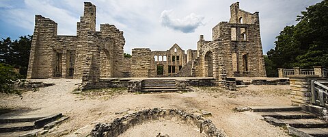
Ha Ha Tonka State Park is a public recreation area encompassing over 5,000 acres (2,000 ha) on the Niangua arm of the Lake of the Ozarks, about five miles south of Camdenton, Missouri, in the United States. The state park's most notable feature is the ruins of Ha Ha Tonka, an early 20th-century stone mansion that was modeled after European castles of the 16th century.
The park also features caves, sinkholes, and bluffs overlooking the lake. It is a prominent example of karst topography, which is geological formation shaped by the dissolution of a layer or layers of soluble bedrock.[5] A 70-acre (28 ha) portion of the park was designated as the Ha Ha Tonka Karst Natural Area in 1981.[6]
History[edit]

Construction of the Ha Ha Tonka castle was started in 1905 by Robert McClure Snyder Sr., a Kansas City businessman who purchased the large property after first visiting there in 1903. Alluding to the natural springs on the property, "ha ha tonka" was said to mean "big laugh" or "smiling waters."[7]
Following Snyder's death in a car accident in 1906, the castle was completed by his sons Robert Jr., LeRoy, and Kenneth Snyder in the early 1920s before the Stock Market Crash. The building was used as a summer and weekend home by the Snyder family, who lived in Kansas City. In the late 1930s, it was used as a hotel; however, it was destroyed by fire in 1942.[8]
The state purchased the castle and grounds in 1978, adapting them for use as a state park and opening them to the public. The water tower was repaired in 2004, with a new roof installed. Although the castle walls were stabilized in the 1980s, a new survey in 2016 determined that portions of the ruins including its arches were seeing mortar and stone failure with the potential beginning of collapse. Some areas have been closed off from the public.[9] The ruins can be seen from an observation point across from the park office.
Activities and amenities[edit]
The park has 15 miles of hiking trails leading to caves, sinkholes, natural bridges, and the castle. The park also features boating, fishing, and swimming.[5]
Trails[edit]
As of 2020, there are 14 trails at the park.[10]
| Trail Name | Description | Length | Notes |
|---|---|---|---|
| Acorn Trail | Moderate hiking trail | 0.9 miles | |
| Big Niangua River Trail | Rough trail made for paddling | 13.4 miles | |
| Boulder Ridge Trail | Moderate hiking trail | 1.5 miles | |
| Castle Trail | Easy trail | 0.4 miles | |
| Cedar Trail | Moderate hiking trail | 0.2 miles | |
| Colosseum Trail | Rugged hiking trail | 0.6 miles | |
| Dell Rim Trail | Moderate hiking trail | 0.3 miles | |
| Devil's Kitchen Trail | Rugged hiking trail | 1.3 miles | |
| Island Trail | Rugged hiking trail | 0.4 miles | |
| Oak Woodland Interpretive Trail | Easy hiking trail | 0.1 miles | |
| Quarry Trail | Moderate hiking trail | 1.7 miles | |
| Spring Trail | Moderate hiking trail | 1.4 miles | |
| Turkey Pen Hollow Trail | Rugged hiking trail | 6.5 miles |
Gallery[edit]
-
 American Castle Panoramic

References[edit]
- ^ "Ha Ha Tonka State Park Visitors Center". Missouri Department of Natural Resources. Retrieved October 7, 2015.
- ^ a b "Ha Ha Tonka State Park". Geographic Names Information System. United States Geological Survey, United States Department of the Interior.
- ^ a b "Ha Ha Tonka State Park: Data Sheet" (PDF). Missouri Department of Natural Resources. November 2017. Retrieved April 24, 2018.
- ^ "State Park Land Acquisition Summary". Missouri State Parks. Retrieved August 18, 2015.
- ^ a b "Ha Ha Tonka State Park". Missouri Department of Natural Resources. Retrieved September 29, 2014.
- ^ "Ha Ha Tonka Karst Natural Area". Missouri Department of Conservation. Retrieved April 24, 2018.
- ^ "Camden County Place Names, 1928–1945". The State Historical Society of Missouri. Retrieved April 24, 2018.
- ^ "Ha Ha Tonka State Park: Park History". Missouri Department of Natural Resources. Retrieved April 24, 2018.
- ^ Wilson, Amy (July 2, 2016). "Landmark ruin in need of repairs". Lake News Online. Retrieved April 24, 2018.
- ^ "Missouri State Parks Trail Inventory". Retrieved July 14, 2021.
External links[edit]
Ha Ha Tonka State Park.
- Ha Ha Tonka State Park Missouri Department of Natural Resources
- Ha Ha Tonka State Park Map Missouri Department of Natural Resources