Dierona: Difference between revisions
Content deleted Content added
No edit summary |
|||
| (24 intermediate revisions by 5 users not shown) | |||
| Line 1: | Line 1: | ||
{{Infobox |
{{Infobox settlement |
||
<!--See |
<!-- See Template:Infobox settlement for additional fields and descriptions --> |
||
<!-- Basic info ----------------> |
<!-- Basic info ----------------> |
||
|official_name =Dierona |
|official_name =Dierona |
||
| Line 9: | Line 9: | ||
|motto = |
|motto = |
||
<!-- images and maps -----------> |
<!-- images and maps -----------> |
||
|image_skyline = |
|image_skyline = View of Dierona 15.jpg |
||
|imagesize = |
|imagesize = 300 |
||
|image_caption = |
|image_caption = |
||
|image_flag = |
|image_flag = |
||
| Line 17: | Line 17: | ||
|seal_size = |
|seal_size = |
||
|pushpin_map = Cyprus<!-- the name of a location map as per http://en.wikipedia.org/wiki/Template:Location_map --> |
|pushpin_map = Cyprus<!-- the name of a location map as per http://en.wikipedia.org/wiki/Template:Location_map --> |
||
|pushpin_relief =y |
|||
|pushpin_label_position =bottom |
|pushpin_label_position =bottom |
||
|pushpin_mapsize = 300 |
|pushpin_mapsize = 300 |
||
| Line 70: | Line 71: | ||
}} |
}} |
||
'''Dierona''' ({{lang-gr|Διερώνα}}) is a village in the [[Limassol District]] of [[Cyprus]], located 2 km south of [[Arakapas]]. |
'''Dierona''' ({{lang-gr|Διερώνα}}) is a semi-mountainous village in the [[Limassol District]] of [[Cyprus]], located 2 km south of [[Arakapas]] at the foothills of the Troodos Mountains. |
||
The population, at the last count, is just over 250 people. |
|||
The village is off the regular mountain tourism ‘beat and track’ and has thus become much sought after with wealthy artisan and business types. |
|||
The village is close to the Wine Routes in the [[Commandaria]] area and stands at an altitude of 461 metres (1512.47 feet). |
|||
A modern road leading down the mountains into Yermasoyia has also helped attract those that wish to live a rural lifestyle, but commute to work. |
|||
It has an arched Venetian Dierona Bridge, the Church of Archangel Michael and [[mandarin orange]] orchards, walnut trees and wooded mountainscape. |
|||
| ⚫ | |||
The village is equidistant between the mountains and the seaside at Amathus in Limassol, and easily reachable by a modern dual-lane road. |
|||
| ⚫ | |||
==References== |
==References== |
||
<references/> |
<references/> |
||
| Line 88: | Line 90: | ||
[[Category: |
[[Category:Communities in Limassol District]] |
||
Latest revision as of 07:07, 9 December 2020
Dierona
Διερώνα | |
|---|---|
 | |
| Coordinates: 34°49′49″N 33°6′40″E / 34.83028°N 33.11111°E | |
| Country | |
| District | Limassol District |
| Population (2001)[1] | |
| • Total | 258 |
| Time zone | UTC+2 (EET) |
| • Summer (DST) | UTC+3 (EEST) |
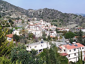
Dierona (Greek: Διερώνα) is a semi-mountainous village in the Limassol District of Cyprus, located 2 km south of Arakapas at the foothills of the Troodos Mountains.
The population, at the last count, is just over 250 people.
The village is close to the Wine Routes in the Commandaria area and stands at an altitude of 461 metres (1512.47 feet).
It has an arched Venetian Dierona Bridge, the Church of Archangel Michael and mandarin orange orchards, walnut trees and wooded mountainscape.
The village is equidistant between the mountains and the seaside at Amathus in Limassol, and easily reachable by a modern dual-lane road.
There is a Golf and Country Club in nearby Vikla.


