Agios Tychonas
|
Agios Tychonas Άγιος Τύχωνας |
||
|---|---|---|
|
|
||
| Basic data | ||
| State : |
|
|
| District : | Limassol | |
| Geographic coordinates : | 34 ° 44 ′ N , 33 ° 8 ′ E | |
| Height above d. M .: |
80 m |
|
| Surface: | 10.4213 km² | |
| Residents : | 3455 (2011) | |
| LAU-1 code no .: | CY-02 | |
| Website: | www.agiostychonas.com | |
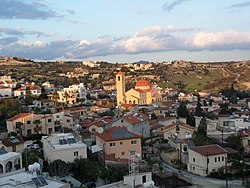
| View of Agios Tychonas | ||
Agios Tychonas ( Greek Άγιος Τύχωνας ) is a municipality in the district of Limassol in Cyprus . At the 2011 census it had 3,455 inhabitants.
Location and surroundings
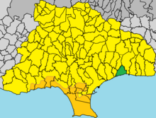
Agios Tychonas is located in the southern center of the island of Cyprus at an altitude of about 80 meters, about 53 km southwest of the capital Nicosia , 6 km east of Limassol and 48 km southwest of Larnaka .
The place reaches up to the Mediterranean coast and is located on the eastern edge of the urban area of Limassol. The old district is located a bit inland, on the more densely built-up coast there are mainly multi-storey hotels and villas behind. The highway 1 runs through the municipality from Nicosia to Limassol and the main road B1 runs directly by the sea . The Germasogia Reservoir is located about 5 kilometers to the northwest .
Places in the area are Armenochori in the north, Pareklisia and behind it Pyrgos in the east, Mouttagiaka and then Germasogia in the west and Finikaria in the northwest.
Web links
- The community site (English)
Individual evidence
- ^ Statistical Service. cystat.gov.cy, accessed April 5, 2019 . (Download)


