Agona East District: Difference between revisions
Content deleted Content added
No edit summary |
No edit summary |
||
| Line 1: | Line 1: | ||
{{Infobox settlement |
{{Infobox settlement |
||
| |
|name = Agona East District |
||
| |
|settlement_type = [[Districts of Ghana|District]] |
||
| |
|native_name = |
||
| |
|nickname = |
||
| |
|image_skyline = |
||
| |
|image_size = |
||
| |
|image_caption = |
||
| |
|image_flag = |
||
| |
|image_seal = |
||
| |
|image_map = Districts of the Central Region (2012).svg |
||
| |
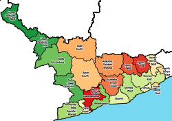
|map_caption = Districts of [[Central Region, Ghana|Central Region]] |
||
| |
|pushpin_map = Ghana |
||
|pushpin_label_position = |
|||
| ⚫ | |||
|pushpin_map_caption = Location of Agona East District within [[Central Region, Ghana|Central]] |
|||
| ⚫ | |||
| ⚫ | |||
| ⚫ | |||
| ⚫ | |||
| ⚫ | |||
| ⚫ | |||
| ⚫ | |||
| ⚫ | |||
| ⚫ | |||
| ⚫ | |||
| government_type = District Assembly |
|||
| ⚫ | |||
| |
|leader_title = District Executive |
||
| |
|leader_name = Martin Luther Obeng |
||
| leader_title1 = <!-- Presiding Member--><!-- for places with, say, both a mayor and a city manager --> |
|||
| ⚫ | |||
| leader_name1 = |
|||
| ⚫ | |||
| ⚫ | |||
|area_magnitude = |
|||
| ⚫ | |||
| |
|area_total_km2 = |
||
| |
|area_land_km2 = |
||
| |
|area_water_km2 = |
||
| ⚫ | |||
| area_water_km2 = |
|||
| ⚫ | |||
| ⚫ | |||
| ⚫ | |||
| ⚫ | |||
| ⚫ | |||
| ⚫ | |||
| ⚫ | |||
| ⚫ | |||
|timezone = GMT |
|||
| ⚫ | |||
|utc_offset = +0 |
|||
| timezone = [[Greenwich Mean Time]] |
|||
| |
|timezone_DST = |
||
| ⚫ | |||
| timezone_DST = [[Greenwich Mean Time|GMT]] |
|||
| ⚫ | |||
| ⚫ | |||
| ⚫ | |||
| ⚫ | |||
|iso_code = GH-CP-__ |
|||
| ⚫ | |||
| |
|blank_name = |
||
| |
|blank_info = |
||
| |
|website = |
||
|footnotes = |
|||
}} |
}} |
||
'''Agona East District''' is one of the twenty-two districts in [[Eastern Region, Ghana|Eastern Region]], [[Ghana]].<ref>[http://ghanadistricts.gov.gh/home/?_=27&sa=3399 District: Agona East District] {{webarchive|url=https://web.archive.org/web/20120323051508/http://ghanadistricts.gov.gh/home/?_=27&sa=3399 |date=2012-03-23 }}</ref> |
'''Agona East District''' is one of the twenty-two districts in [[Eastern Region, Ghana|Eastern Region]], [[Ghana]].<ref>[http://ghanadistricts.gov.gh/home/?_=27&sa=3399 District: Agona East District] {{webarchive|url=https://web.archive.org/web/20120323051508/http://ghanadistricts.gov.gh/home/?_=27&sa=3399 |date=2012-03-23 }}</ref> Originally it was formerly part of the then-larger '''[[Agona District]]''' in 1988, until the eastern part of the district was split off to create '''Agona East District''' on 29 February 2008; thus the remaining part has been renamed as '''[[Agona West District]]''', which was also elevated to municipal district assembly status on that same year to become '''[[Agona West Municipal District]]'''. The district assembly is located in the northeast part of Central Region and has [[Nsaba]] as its capital town. |
||
==List of settlements== |
==List of settlements== |
||
| Line 72: | Line 73: | ||
{{Central Region, Ghana}} |
{{Central Region, Ghana}} |
||
{{coord|5|38|35.88|N|0|45|2.88|W|region:GH|display=title}} |
|||
[[Category:Central Region (Ghana)]] |
|||
[[Category:Districts of the Central Region (Ghana)]] |
[[Category:Districts of the Central Region (Ghana)]] |
||
Revision as of 20:33, 12 June 2021
Agona East District | |
|---|---|
 Districts of Central Region | |
Location of Agona East District within Central | |
| Coordinates: 5°38′35.88″N 0°45′2.88″W / 5.6433000°N 0.7508000°W | |
| Country | |
| Region | |
| Capital | Nsaba |
| Government | |
| • District Executive | Martin Luther Obeng |
| Time zone | UTC+0 (GMT) |
| ISO 3166 code | GH-CP-__ |
Agona East District is one of the twenty-two districts in Eastern Region, Ghana.[1] Originally it was formerly part of the then-larger Agona District in 1988, until the eastern part of the district was split off to create Agona East District on 29 February 2008; thus the remaining part has been renamed as Agona West District, which was also elevated to municipal district assembly status on that same year to become Agona West Municipal District. The district assembly is located in the northeast part of Central Region and has Nsaba as its capital town.
List of settlements
| Settlements of Upper Denkyira East Municipal Assembly | |||
| No. | Settlement | Population | Population year |
|---|---|---|---|
| 1 | Nsaba | ||
Sources
References
- ^ District: Agona East District Archived 2012-03-23 at the Wayback Machine


