
Hurricane Gladys (1964)
| hurricane | |
|---|---|
| Formed | September 13, 1964 |
| Dissipated | September 25, 1964 |
Hurricane Gladys was the ninth tropical cyclone (including two unnamed tropical storms), seventh named storm, fourth hurricane and fourth major hurricane of the 1964 Atlantic hurricane season.[1] Gladys formed from on September 13, 1964 as a tropical depression and moved westward where it quickly became a category 4 hurricane. Gladys reached a peak intensity of 145 mph (225 km/h) before recurving to the northeast and brushing past eastern North Carolina and Atlantic Canada. Gladys then became extratropical dissapated on September 25.
Although the storm stayed offshore, Gladys managed to cause moderate beach erosion and flood damage in the Outer Banks of North Carolina. Overall damage was minor and there was only one direct fatality as the result of the storm.
Storm history

Tropical storm (39–73 mph, 63–118 km/h)
Category 1 (74–95 mph, 119–153 km/h)
Category 2 (96–110 mph, 154–177 km/h)
Category 3 (111–129 mph, 178–208 km/h)
Category 4 (130–156 mph, 209–251 km/h)
Category 5 (≥157 mph, ≥252 km/h)
Unknown
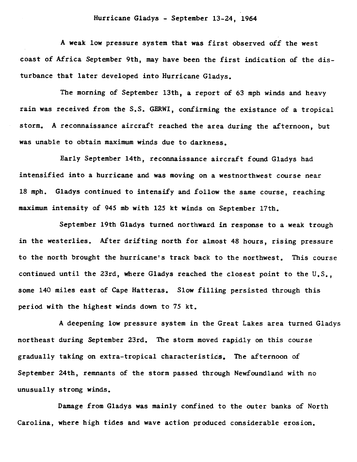
A weak tropical wave moved off the coast of Africa on September 9 and moved westward across the Atlantic Ocean. On September 13, a ship reported winds of 63 mph (101 km/h) confirming a that the distubance had rapidly became a tropical storm. As a result, the National Hurricane Center named the storm Gladys. A hurricane hunter plane flew into Gladys but was unable to obtain wind data due to darkness.[2]
The following day, the hurricane hunter plane flew into Gladys again and the crew determined that the storm had rapidly reached hurricane status as it moved west-northwest at 18 mph. Gladys continued on that heading as it reached Category 4 status. On September 17, Gladys winds peaked at 145 mph (225 km/h) and the barometric pressure dropped to 945millibars.[2]
On September 19 a weak trough caused Gladys to turn northward and weaken to a Category 3 hurricane and later to a Category 2 hurricane. Gladys drifted northward for 48 hours before turning to the northwest again. Gladys then turned to the northeast on September 23 in reponse of a developing area of low pressure over the Great Lakes. The center of the storm reached its closest proximity to the East Coast of the United States by 150 miles (241 km). Gladys then weakakened to a minimal hurricane as it continued moving northeastward.[2][3]Gladys then accelerated rapidly and became extratropical on September 23. The extratropical remnants of Gladys brushed past Nova Scotia and passed over Newfoundland on September 24 and dissapated on September 25.[2]
Preparations
As Gladys strengthened in the Atlantic Ocean, forecasters at the National Hurricane Center predicted that the storm will bring high surf to areas as far north as North Carolina and suggested that Gladys might head towards northern Florida as the storm was on a similar path as Hurricane Dora. As a result, forecasters advised residents along the southeastern coast of the United States and small craft advisories were issued.[4][5] On September 20, the concern of Gladys hitting Florida dwindled as the storm turned northeast and small craft advisories were issued for the Bahamas.[6]
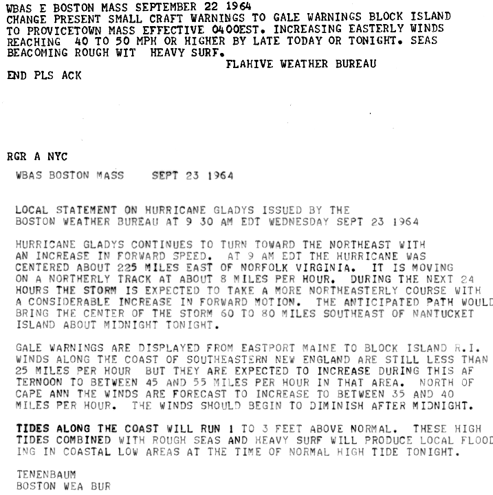
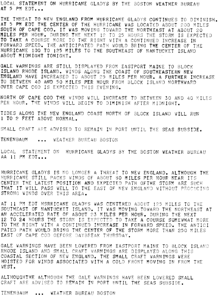
On September 22, Gladys turned back towards the northwest, prompting forecasters at the National Hurricane Center to place the states of North Carolina, Virginia and Mid Atlantic under a hurricane watch. [7]Gale warnings and small craft advisories were issued on September 23 from Massachusetts to Rhode Island.[8]In Rhode Island, ships of the United States Navy were diverted to Narraganselt Bay as a precaution.[9] At 11PM (est), the gale warnings for New England were lowered as Gladys turned northeastward away from the coast however, small water craft were advised to remain in port untill the seas subside.[10]
Impact
Hurricane Gladys windfield extended 275 miles (443 km) from the center and produced rough seas that affected the eastern Caribbean, northern Bahamas and coastal sections of Florida and Georgia.[4][6]
Carolinas and Virginia
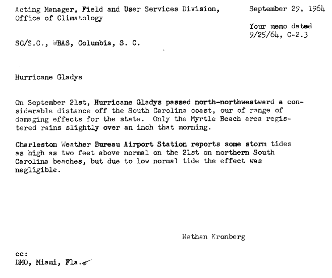
Hurricane Gladys effects on South Carolina was minimal as the center of the hurricane was a considerable distance from the coastline. The only effects Gladys brought to South Carolina was an 1 inch (25.4 mm) of rainfall which was reported in Myrtle Beach and storm tides two feet (0.6 meters) above normal.[11]
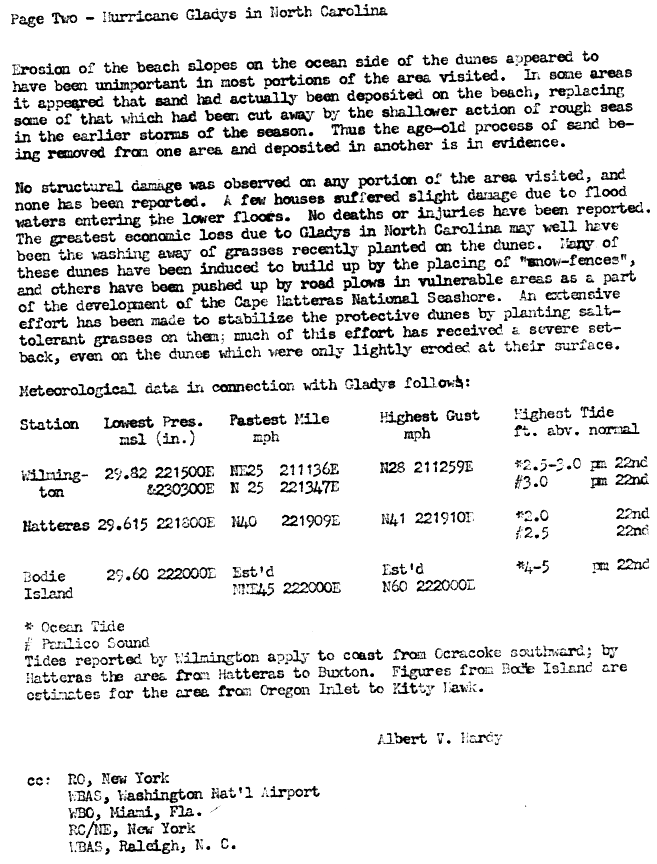
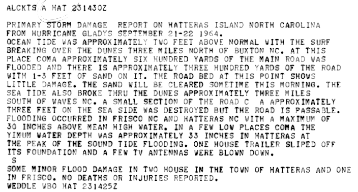
In North Carolina, Gladys large windfield produced strong tropical storm force winds near Manteo. Waves produced by the strong winds flooded a highway leading away from Manteo. Near Cape Hatteras, a weather station recorded winds of 40 mph (65 km/h) with gust up to 41 mph (66 km/h) and tides 2-2.5 feet (0.6-0.76 meters) above normal.[12] The abnormal tides and heavy wave action flooded two small villages, leaving many homes and buildings under 2 feet (0.6 meters) of water[9]and washed way grasses that were planted to stablize the sand dunes.[12] A weather station in Wilmington reported winds of 25 mph (40 km/h) with a peak gust of 28 mph (45 km/h)[13]and tides 2-3 feet (0.6-0.9 meters) above normal.[12] Elsewhere in the Outer Banks, high winds caused a mobile home to fall off its foundations and blew down two television antennas.[14]
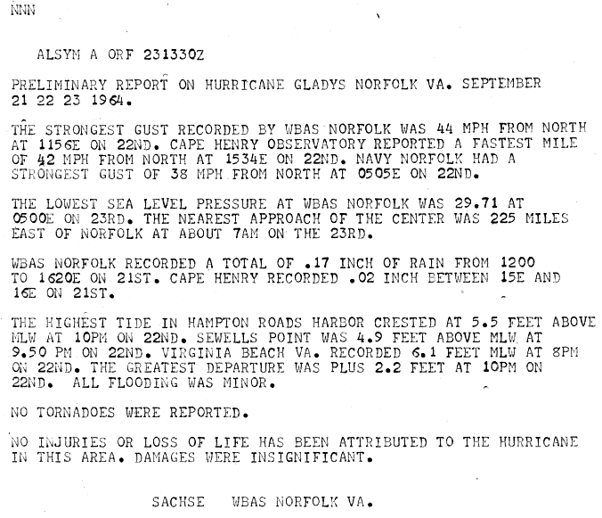
In Virginia, a weather station in Norfolk recorded gusts of 38-44 mph (61-71 km/h), a barometric pressure of 29.71 inches (1006 millibars) and .17 inches (4.31 mm) of rain. A weather station in Cape Henry recorded sustained winds of 42 mph (68 km/h)and rainfall of .02 inches (0.5 mm). Coastal sections of southeastern Virginia experienced tides 2.2-6.1 feet (0.6-1.8 meters) above normal, resulting in minor tidal flooding. [15]One indirect fatality was attibuted from Gladys when a man suffered fatal wounds to his throat due to flying debris.[16]
Northeast United States, Bermuda and Canada
High winds and strong ocean currents form Gladys produced heavy surf and beach erosion in New Jersey, New York and Massachutess.[17] In Rhode Island, the outerbands of Gladys produced light rainfall of .38 inches across the state.[18] In Narragansett, Rhode Island, a boy was washed into the sea by the waves and was rescued by the United States Coast Guard servicemen who dove into the water to rescue the boy after two previous attempts to rescue him failed.[19] The outer bands of Gladys also lashed Bermuda with winds but little damage if any was reported.
See also
References
- ^ Unisys (2007). "Unisys 1964 Archive". Retrieved 2007-02-22.
- ^ a b c d "Hurricane Gladys report page 1". NOAA. 1964. Retrieved 2007-02-22.
{{cite web}}: Text "National Hurricane Center" ignored (help) - ^ Weather Underground (2007). "Weather Underground Archive of Gladys". Retrieved 2007-02-22.
- ^ a b United Press International (1964). "Hurricane Gladys, Big and Dangerous". The Times Recorder. Retrieved 2007-02-27.
- ^ UPI (1964). "Hurricane Gladys plods towards Carolinas". The Valley Independent. Retrieved 2007-02-27.
- ^ a b AP and UPI (1964). "Hurricane Moving on Georgia". Oakland Tribune. Retrieved 2007-02-27.
- ^ AP (1964). "Shore put on Hurricane Watch". The Salisbary Times. Retrieved 2007-02-27.
- ^ Tenenbaun (1964). "NWS Advisory on Gladys". NOAA. Retrieved 2007-03-01.
- ^ a b Newport Daily News (1964). "Navy City takes storm precautions". Retrieved 2007-03-01.
- ^ Tenenbaum (1964). "NWS Advisory on Gladys". NOAA. Retrieved 2007-03-02.
- ^ Nathan Kronberg (1964). "South Carolina report on Gladys". NOAA. Retrieved 2007-03-02.
- ^ a b c Hardy (1964). "Hurricane Gladys Report page 3". NOAA. Retrieved 2007-03-16.
- ^ Duke (1964). "Wilmington, North Carolina report on Gladys". NOAA. Retrieved 2007-03-16.
- ^ Weddle (1964). "Hurricane Gladys damage report". NOAA. Retrieved 2007-03-16.
- ^ Sasche (1964). "Norfolk report on Gladys". NOAA. Retrieved 2007-03-16.
- ^ AP (1964). "East Coast Sparred as Hurricane Veers". Oshkosh Daily Northwestern. Retrieved 2007-03-19.
- ^ AP (1964). "Fickle Gladys heads away into open sea". The Greeley Daily Tribune. Retrieved 2007-03-19.
- ^ AP (1964). "Hurricane only brought heavy rains, crashing seas to R.I." The Newport Daily News. Retrieved 2007-03-19.
- ^ Independant News (1964). "Ocean Ordeal: I Thought I Was Going to Die". Retrieved 2007-03-19.